Nizhny Novgorod province During the regional reform of Peter I in 1708, Nizhny Novgorod was included in the Kazan province. In January 1714, a new Nizhny Novgorod province was separated from the northwestern parts of the Kazan province. In addition to Nizhny Novgorod, the province included the cities of Alatyr, Arzamas, Balakhna, Vasilsursk, Gorokhovets, Kurmysh, Yuryevets, Yadrin with adjacent territories. In 1717, the province was abolished, and the territories returned to the Kazan province.
On May 29, 1719, as a result of the Second Peter's reform, the Nizhny Novgorod province was again recreated. It included 3 provinces: Alatyr, Arzamas, Nizhny Novgorod and 7 cities.
During the administrative reform of Catherine II on September 5, 1779, the Nizhny Novgorod governorate was established, which included the old Nizhny Novgorod province, as well as parts of the previously formed Ryazan and Vladimir governorships and part of the Kazan province.
On December 12, 1796, under Paul I, the Nizhny Novgorod governorate was renamed into a province.
In October 1797, the size of the Nizhny Novgorod province was increased due to the territories received during the division of the Penza province. After the accession of Alexander I to the throne on September 9, 1801, the Penza province was restored to its previous extent.
Due to zemstvo reform Since 1865, the institution of local government - zemstvo - was introduced in the Nizhny Novgorod province.
After October Revolution In 1917, the Nizhny Novgorod province became part of the Russian Soviet Federative Formation formed in 1918. Socialist Republic(RSFSR).
In 1922, the province included Varnavinsky and Vetluzhsky districts of the Kostroma province, Kurmyshsky district Simbirsk province and a small part of the Tambov province.
By a resolution of the Presidium of the All-Russian Central Executive Committee of January 14, 1929, the provinces were completely liquidated. On the territory of the Nizhny Novgorod province it was formed Nizhny Novgorod region, it also included the territory of the abolished Vyatka province and small sections of the Vladimir and Kostroma provinces.
Nizhny Novgorod province presented:
- Odnolayout(1 verst in one English inch) - 1 cm = 420 meters, one of the most detailed maps from those available in the province.
Available:
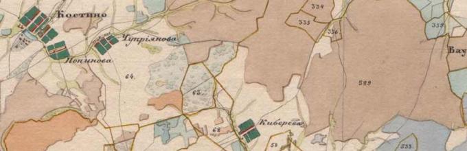
1-layout of the Nizhny Novgorod province of Mende, 1850s.
One-page map of Mende - topographical (latitudes and longitudes are indicated on it), drawn map of the mid-19th century. (after the next changes in the boundaries of the provinces of Russia in 1802-03), very detailed - on a scale of 1 inch 1 verst or 1 cm - 420 m. The province is divided into squares shown on the collection sheet.

The card contains litera-ru stamps, the quality of the scans is excellent.
Maps of Nizhny Novgorod province
Detailed ancient maps of the Nizhny Novgorod province (region) 20th century, 19th century, 18th century
The date of formation of the Nizhny Novgorod province is 1779. It included 3 provinces (Nizhny Novgorod, Alatyr and Arzamas) and 6 counties. The population at the beginning of the 20th century was 1,799,500 people, and the total area of the territory was 51,252 km 2.
In our electronic library Maps of the Nizhny Novgorod province are available. We are digitizers of ancient maps, survey maps and economic notes - write orders by email!
View more details and for free (everything on the current page is paid)
Available:
4 layouts without a year.(Makaryevsky district)
Non-topographic map of reading institutions. The scale is set by eye. The scale is 1 inch = 4 versts or 1 cm = 1680 m.
The map is monocolor, non-detailed. There is no collection sheet as it is unnecessary.
- see sample map
See sample | prefabricated sheet Ardatovsky district
quantity: 19 A3 files (in five parts), the county is made along the borders of Catherine
See sample | prefabricated sheetArzamas district
quantity: 18 A3 files (in five parts), the county is made along the borders of Pavel
See sample | prefabricated sheetBalakhninsky district
quantity: 12 A3 files (in three parts), there are two versions of the map of Balakhninsky district of varying degrees of preservation
 Gorbatovsky district
quantity: 12 A3 files, there are two versions of the map of Gobatovsky district of varying degrees of preservation, the meaning of the second version of the map of Gorbatovsky district is to correspond to the numbers from the EP
See sample | prefabricated sheetLukoyanovsky district
quantity: 16 A3 files (in four parts) in those borders when the map of Lukoyanovsky district partially included Pochinkovsky district with the city of Pochinki and did not border with Sergachsky, at the border with which there were Knyagininsky district and Arzamas district
See sample | prefabricated sheetPochinkovsky district
quantity: 16 A3 files (in four parts)
Economic notes of Gorbatovsky district, alphabet of Mende dachas
Economic notes of Balakhninsky district, alphabet of Mende dachas
quantity: about 100 sheets, handwritten, useful for 100% linking of dachas to the map of Mende of the Nizhny Novgorod province
Expected:
-General survey plan Nizhny Novgorod province on a scale of 1 inch = 1-2 versts
Year of publication - approximately 1790s.
-Non-topographical map, color
To order PGM - inventory according to RGADA:
Provincial map m-4 c. Nizhny Novgorod province
Map of the Nizhny Novgorod Viceroyalty (for the 13th uyezd) Nizhny Novgorod province
Same m-8 v. Nizhny Novgorod province
Provincial map (for 10 districts) m-4 c. Nizhny Novgorod province 1798
The same (unfinished) Nizhny Novgorod province
"Map for the passage of troops - Nizhny Novgorod province" m-10 century. Nizhny Novgorod province 1799
Provincial map m-16th century. Nizhny Novgorod province
Map of Yaroslavl, Kostroma and Nizhny Novgorod provinces with their districts m-24 century. Nizhny Novgorod province
General district plan m-1 c. Nizhny Novgorod province Ardatov district 1791
The same - 2nd copy. Nizhny Novgorod province Ardatov district
General district plan m-1 c. Nizhny Novgorod province Ardatov district 179..
District map m-4 v. Nizhny Novgorod province Ardatov district
The same (rough) m-4 c. Nizhny Novgorod province Ardatov district
District map m-8 v. Nizhny Novgorod province Ardatov district
The same - 2nd copy. m-8 c. Nizhny Novgorod province Ardatov district
General district plan (atlas) in 5 parts. Part 1 m-2 v. Nizhny Novgorod province Ardatov district
Part 2 Nizhny Novgorod province Ardatov district
continuation >>>
To order an EP - inventory according to RGADA:
1. Brief provincial report card. 1 Tables No. 788-792 have different data for the Nizhny Novgorod province (1784-1797).
2. Same. 1 Nizhny Novgorod province (1784-1797).
3. Same. 1800 1 Nizhny Novgorod province (1784-1797).
4. Same. 1 Nizhny Novgorod province (1784-1797).
5. Same. 1 Nizhny Novgorod province (1784-1797).
6. Alphabet of dachas in thirteen counties. 64 m.f. Nizhny Novgorod province (1784-1797).
7. Alphabet of villages, churchyards and other settlements, indicating their distance from the provincial and district cities, the amount of church land, etc. 58 m.f. Nizhny Novgorod province (1784-1797).
8. Economic notes on 268 dachas (dacha numbers 221-268 were added later), alphabets of dachas and owners and time sheets. m.f. Nizhny Novgorod province Ardatov district
9. Economic notes on 220 dachas. 40 m.f. Nizhny Novgorod province Ardatov district
10. Alphabets of dachas and owners. 8 m.f. Nizhny Novgorod province Ardatov district
11. Alphabets of owners. 4 m.f. Nizhny Novgorod province Ardatov district
12. Alphabets of dachas and owners. 1800 24 m.f. Nizhny Novgorod province Ardatov district
13. Brief report card. 1 Nizhny Novgorod province Ardatov district
14. Economic notes on 331 dachas (dacha numbers 320-331 were added later), alphabets of dachas and owners and time sheets. m.f. Nizhny Novgorod province Arzamas district
Administrative-territorial unit Russian Empire and the RSFSR, which existed in 1714-1929. Provincial city - Nizhny Novgorod.
The Nizhny Novgorod province bordered on the following provinces: in the west - with, in the north - with and, in the east - with and, in the south - with and.
History of the formation of the Nizhny Novgorod province
During the provincial division of 1708, carried out in the course of the regional reforms of Peter I, Nizhny Novgorod was included in the Kazan province. Since January 1714, the northwestern part of its territory was allocated to the Nizhny Novgorod province. In addition to Nizhny Novgorod, the province included the cities of Alatyr, Arzamas, Balakhna, Vasilsursk, Gorokhovets, Kurmysh, Yuryevets, Yadrin with adjacent territories. In 1717, the province was abolished, the territories returned to the Kazan province, but two years later, by decree of Peter I of May 29, 1719, the Nizhny Novgorod province was again recreated.
During the administrative reform of Catherine II in 1778, the territories of the Nizhny Novgorod province first became part of the Ryazan governorate, and in 1779 the Nizhny Novgorod governorship was established, which included the old Nizhny Novgorod governorate, as well as parts of the Ryazan and Volodymyr (Vladimir) governorships and part of the Kazan governorate. Under Paul I, the reverse renaming took place: governorships were renamed into provinces.
In October 1797, the size of the Nizhny Novgorod province was increased due to the territories received during the division of the Penza province. After the accession of Alexander I to the throne on September 9, 1801, the Penza province was restored to its previous extent.
When the Nizhny Novgorod governorate was formed in 1779, it was divided into 13 districts. In 1796, when the governorship became a province, the Knyagininsky, Makaryevsky, Pochinkovsky, Pyansk-Perevozsky and Sergachsky districts were abolished. In 1804, Knyagininsky, Makaryevsky and Sergachsky districts were restored. As a result, until 1917, the Nizhny Novgorod province included 11 districts:

| № | County | County town | Area, verst | Population (1897), people |
|---|---|---|---|---|
| 1 | Ardatovsky | Ardatov (3546 people) | 5288,0 | 141 625 |
| 2 | Arzamas | Arzamas (10,592 people) | 3307,1 | 138 785 |
| 3 | Balakhninsky | Balakhna (5120 people) | 3688,6 | 141 694 |
| 4 | Vasilsursky | Vasilsursk (3799 people) | 3365,9 | 127 333 |
| 5 | Gorbatovsky | Gorbatov (4604 people) | 3190,1 | 134 160 |
| 6 | Knyagininsky | Knyaginin (2737 people) | 2595,5 | 106 191 |
| 7 | Lukoyanovsky | Lukoyanov (2117 people) | 5127,5 | 193 454 |
| 8 | Makarievsky | Makaryev (1560 people) | 6568,2 | 108 994 |
| 9 | Nizhny Novgorod | Nizhny Novgorod (90,053 people) | 3208,2 | 222 033 |
| 10 | Semyonovsky | Semenov (3752 people) | 5889,2 | 111 388 |
| 11 | Sergachsky | Sergach (4530 people) | 2808,4 | 159 117 |
After the revolution of 1917, the composition of the Nizhny Novgorod province underwent significant changes.
- 1918 - Gorbatovsky district was renamed Pavlovsky. Voskresensky district was formed.
- 1920 - Makaryevsky district was renamed Lyskovsky.
- 1921 - Balakhninsky district was renamed Gorodetsky. Vyksa, Pochinkovsky and Sormovsky districts were formed.
- 1922 - the following were added to the province: Varnavinsky and Vetluzhsky districts of the Kostroma province, 6 volosts of the abolished Koverninsky district of the Kostroma province; almost the entire Kurmysh district of the Simbirsk province, 4 volosts of the Tambov province. The Kanavinsky working district was formed.
- 1923 - Ardatovsky, Varnavinsky, Vasilsursky, Voskresensky, Knyaginsky, Kurmyshsky and Pochinkovsky districts were abolished. Krasnobakovsky district was formed.
- 1924 - four volosts were transferred to the Mari Autonomous Region, one volost to the North Dvina province. The Balakhninsky and Rastyapinsky working districts were formed. Sormovsky district was transformed into a working district.
Thus, in 1926, the Nizhny Novgorod province included 11 counties and 4 districts.
Additional materials on the Nizhny Novgorod province
- Plans for general land surveying of the districts of the Nizhny Novgorod province
Ardatovsky district 2 versts - Arzamas district 2 versts - Balakhninsky district 2 versts - Gorbatovsky district 2 versts - Knyagininsky district 2 versts - Lukoyanovsky district 2 versts - Makaryevsky district 2 versts - Nizhny Novgorod district 2 versts - Semenovsky district 2 versts - Sergach district 2 versts - Vasilsky district 2 versts - - Lists of populated places of the Russian Empire, compiled and published by the Central Statistical Committee of the Ministry of Internal Affairs. - St. Petersburg: in the printing house of Karl Wulff: 1861-1885.
Nizhny Novgorod province: according to information from 1859 / processed by Art. ed. E. Ogorodnikov. - 1863. - XXXIII, 186 pp., color. kart. . - The First General Census of the Russian Empire in 1897 / ed. [and with a preface] N.A. Troinitsky. — [St. Petersburg]: publication of the Central Statistical Committee of the Ministry of Internal Affairs: 1899-1905.
Nizhny Novgorod province. tetr. 1. - 1901. - 140 p., l. color kart. . - The First General Census of the Russian Empire in 1897 / ed. [and with a preface] N.A. Troinitsky. — [St. Petersburg]: publication of the Central Statistical Committee of the Ministry of Internal Affairs: 1899-1905. Nizhny Novgorod province. tetr. 2 (last). - 1904. - , XVI, 227 p. .
- Essay on the Nizhny Novgorod province in historical and geographical terms: (materials for homeland studies of the Nizhny Novgorod province) / Comp. M. Ovchinnikov, inspector school Nizhegorod. lips — Nizhny Novgorod: Type. Lip. gov., 1885. - , XIII, 60 p. .
- On the composition and movement of the population in the provinces of Nizhny Novgorod and Yaroslavl: extracted. by order of M-va ext. cases, from information, collected. special stat. expeditions: [stat. table]. - St. Petersburg: Printing house of S. N. Bekenev, 1861. - , 79, 108 p. .


The Nizhny Novgorod province was established in 1714 during the administrative reform of Peter the Great in the territories included in 1708 in the Kazan province (northwest of this province) with the cities of Alatyr, Arzamas, Balakhna, Vasilsursk, Gorokhovets, Kurmysh, Yuryevets, Yadrin and their surrounding lands. However, in 1717, the Nizhny Novgorod province was abolished, and its lands were again included in the Kazan province. In 1719, the Nizhny Novgorod province was restored as part of 3 provinces (Alatyr, Arzamas, Nizhny Novgorod) and 7 cities. In 1779, under Catherine II, the Novgorod governorate was established, which included the entire territory of the former Nizhny Novgorod province, as well as part of the lands that were previously under the administrative subordination of the provinces of Ryazan, Vladimir, and Kazan. (see ending below)
In the Nizhny Novgorod province in whole or in part
There are the following maps and sources:
(except for those indicated on the main page of the general
All-Russian atlases, which may also include this province)
 2nd layout of land surveying (1778-1797)
A two-layout map of land surveying - non-topographic (it does not indicate latitudes and longitudes), a hand-drawn map of the last decades of the 18th century, very detailed - on a scale of 1 inch 2 versts or in 1 cm 840 m. A single county was drawn in fragments, on several sheets, shown on a single composite sheet. The purpose of the survey map is to indicate the boundaries of private land plots (so-called dachas) within the county.
 1-layout of the Nizhny Novgorod province of Mende, 1850s.
One-page map of Mende - topographical (latitudes and longitudes are indicated on it), drawn map of the mid-19th century. (after regular changes in the borders of Russian provinces in 1802-03), very detailed - on a scale of 1 inch 1 verst or 1 cm 420 m. The province is divided into squares shown on the collection sheet.
We have at our disposal a full-size electronic version maps of the Nizhny Novgorod province Mende 1b with a resolution of 300 dpi.
 Lists of populated places in the Nizhny Novgorod province 1863 (according to 1859 data)
- status of a settlement (village, hamlet, hamlet - proprietary or state-owned, i.e. state);
- location of the settlement (in relation to the nearest highway, camp, river or river);
- distance from county town and the camp apartment (the center of the camp) in versts;
- presence of a church, chapel, mill, etc.
 Lists of water supply to villages of Nizhny Novgorod province 1914
List populated areas- it's universal reference book, containing the following information:
- status of the locality (village, hamlet, hamlet);
- location of the settlement (in relation to the nearest highway, camp, well, pond, stream, river or river);
- number of yards in locality and its population;
- distance from the county town, postal station or railway road in versts;
- etc.
 Economic notes to General Survey Nizhny Novgorod province
In the Nizhny Novgorod province economic notes all counties handwritten
Under Paul the First in 1796, as a result of reorganization, the Nizhny Novgorod governorship began to be called a province. At the same time, the counties of Knyagininsky, Makaryevsky, Perevozsky, Pochinkovsky (the last two were not subsequently restored), and Sergachsky were abolished. In 1797, the Nizhny Novgorod province included lands from the Penza province, abolished at the same time. The last changes in the administrative boundaries of the Nizhny Novgorod province and its composition took place during the reign of Alexander the First (in September 1801), when the lands that previously belonged to the Penza province (Krasnoslobodskaya district), which were restored at that time to their previous borders, were excluded from the province. As part of the Nizhny Novgorod province itself, the districts of Knyagininsky, Makaryevsky, and Sergachsky were simultaneously restored. Throughout the subsequent pre-revolutionary period of the history of the Nizhny Novgorod province, its borders and the composition of the districts did not change.
land surveying inexpensive