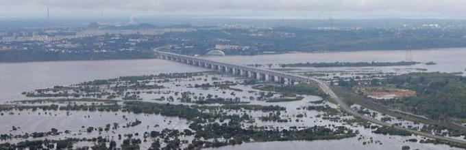
In August 2013, a huge flood occurred, which affected 98 thousand residents. The Amur, the largest river in these places, overflowed its banks. Scientists called the flood the largest in the last hundred years. The river flooded areas located thirty kilometers from its usual course.
The scale of the tragedy made many people think about why the Amur is overflowing, and whether it is possible to somehow prevent the disastrous consequences of the flood.
A little theory
Rivers that are located in sharply defined seasons or originate high in the mountains, among glaciers, always have high water and low water. In nature, there is an eternal exchange of water. Moisture evaporates from the oceans and turns into clouds that carry precipitation. Rain, falling on the ground, penetrates and saturates the rivers, which, in turn, carry their waves to the sea. Therefore, before you figure out why Cupid overflows, you need to understand what it feeds on.
River specifics
We are accustomed to the fact that the rivers of Russia experience high water in the spring, since the vast majority of them are fed by snow. When it gets warm, meltwater overflows the Volga, Oka, Dnieper and similar blue arteries. Low water (the shallowest in them occurs in the summer and the first half of autumn, when there is little precipitation. But the Amur is not such a typical river. It flows in the monsoon climate zone, characterized by the fact that in the summer eastern winds blow here with Pacific Ocean.

It is in climatic features that one should look for the answer to the question of why the Amur floods.
Winters in this region are harsh, but with little snow. Somewhere in November in the Amur basin, as well as on its tributaries - Zeya, Bureya, Ussuri and Sungari - freeze-up begins, which opens only in early May. For almost six months, these rivers receive only underground nutrition - from groundwater and springs. Due to the lack of snow in the winter, spring floods are not observed on local rivers.

But when the summer monsoons begin to blow, bringing heavy rains and typhoons from Okhotsk, the water level in the Amur River and its tributaries rises sharply, since these rivers are fed mainly by rain.
Is it possible to prevent a disaster?
If floods in the Amur occur every summer, then why is August 2013 inscribed in the history of Russia as a black date? There is also something like this geographical concept like a flood. It comes from the violence of the elements and has a sudden, very sharp character. Flood occurs due to heavy and prolonged downpours (for example, when the monthly norm of precipitation falls in 1-2 days) or due to sudden melting of snow in the mountains. And in 2013, a typhoon was added to the action of the humid summer monsoon. An important factor was that the storm did not drive river waters from the shallow estuary back inland. and dam failure. Thus, it is not enough to know why the Amur floods, you also need to realize that August-September is the time of typhoons.
Is it possible to solve the problem? Yes, as the experience of many countries shows. The same Chinese, whose settlement territory runs along the other bank of the Amur, are investing a lot of money to strengthen it from erosion. In Europe, a cascade of reservoirs is installed in the upper reaches of rivers and tributaries. This life-saving chain makes it possible to accumulate excess water and then gradually release it down during low water. We need to adopt this experience, and not be content with the fact that the level of Amur today is within normal limits.
Subject: " Far East» 8th grade
The Far East is washed by the seas of the Pacific Ocean…………………………. ………………………......................................... ............................................
Relief of the Far East - …………………………….since – this is the area ………………………………………………………………………………..
The ridges of the Far East are elongated - ………………………………………………………
not completed, this is evidenced by………………………………………………………………
Climate of the Far East………………………………………………………………..
Precipitation here falls more often in the form of …………………………………….
The most large river Far East - ………………………It has large tributaries ……………………………………………………………
Rivers flood during ………………………………………………..
There is a special forest in Primorye, it is called the “Ussuri taiga” - in fact, it is …………………………………………………………………….
colder because ………………………………………………………
Answers:
The Far East is washed by the seas of the Pacific Ocean - ... (Beringovo, Okhotsk, Japanese).
Relief of the Far East -…. (mountainous) because – this area……….. .... (Cenozoic folding).
The ridges of the Far East are elongated - ……… (from north to south or along the coast).
Mountain building in the Far East has not been completed, this is evidenced by... (earthquakes, volcanism).
Climate of the Far East…… (monsoon).
Precipitation here occurs more often in the form of …(rain)…(summer, winter, spring).
The largest river in the Far East is…… (Amur). It has large tributaries... (Zeya, Bureya, Ussuri).
Rivers flood during... (monsoon rains).
There is a special forest in Primorye, it is called the “Ussuri taiga” - in fact, it is......( mixed forest).
The city of Vladivostok is located at the same latitude as Sochi, but summer in Vladivostok is colder because...... (cools the Pacific Ocean, over which sea air is formed in the summer (the ocean did not have time to warm up in the summer), brought by the monsoons).
To the lesson " Natural resources Far East" 8th grade
Geographic digital dictation
Arrange the numbers for natural complexes if the feature corresponds to the complex.
Chukotka:
Kamchatka:
Sakhalin:
Commander Islands:
Ussuri taiga:
Signs:
Here grow: Amur velvet, Manchurian walnut, Amur grapes, etc.
This territory of the Far East was discovered by Vladimir Atlasov.
This is the coldest part of the Far East.
There are many active volcanoes in the Eastern Ridge.
The origin of the ridge is volcanic.
The population uses thermal waters as a recreational resource.
“Everything here is not like ours. Everything is the same, but not the same. Squirrels are not red, but black. Magpies are blue."
A.P. visited the island here. Chekhov.
The highest peak of the Far East is Klyuchevskaya Sopka.
Researchers of this natural complex – famous traveler N.M. Przhevalsky and writer V.K. Arsenyev.
Here they say “12 months is winter, and the rest of the time is summer”
The attraction of this PTK is the grandiose fir grove.
There are large fur seal rookeries here.
Lake Khanka is the largest lake in the Far East.
In 1995, an earthquake destroyed the city of Neftegorsk.
The natural uniqueness of the Far East - the Valley of Geysers is located in this PTK.
This territory occupies one of the first places in Russia in terms of the number of endemics.
Here, most of the territory is occupied by a subzone of coniferous-birch park forests with a predominance of stone and Japanese birches.
The population grows rice and soybeans.
Vitus Bering is buried on one of them.
Answers:
Chukotka: 3.11
Kamchatka: 2,4,6,9,12,16,18
Sakhalin: 8.15
Commander Islands: 5,13,20
Ussuri taiga: 1,7,10,14,17,19
This lesson will allow students to form an idea of the nature of the Far East. Introduce the history of the discovery, exploration and settlement of the Far East. Deepen knowledge about the interrelations of natural components. Show the unique nature of the Far East. Develop the ability to work with different sources information.
Download:
Preview:
Lesson Far East: land of contrasts
Goals and objectives of the lesson:
To form an idea of the nature features of the Far East. Introduce the history of the discovery, exploration and settlement of the Far East. Deepen knowledge about the interrelations of natural components. Show the unique nature of the Far East. Develop the ability to work with different sources of information.
Equipment:
Maps: physical Russia, maps of the Far East, climatic, tectonic Russia, paintings, tables, books ( documentary). Nature of the Far East. Sheets - programs on the desk.
During the classes
I. Organizational moment
II. Repetition. Checking homework
Test tasks
1. First information about Eastern Siberia appeared in Russia:
a) in the 10th century; b) in the 15th century; c) in the 18th century; d) in the 19th century.
2. Mangazeya, founded in 1601 Western Siberia, was later moved to the mouth of the Lower Tunguska and renamed in 1782:
a) to Turukhansk; b) to Norilsk; c) to Krasnoyarsk.
3. The Central Siberian Plateau is located:
a) on a fashionable stove;
b) on the folded area;
c) on an ancient platform;
d) on the shield.
4. The highest mountains of Eastern Siberia:
a) Sayan Mountains; b) Byrrranga; c) Altai; d) Pamir.
a) the city of Munku-Sardyk; b) Belukha; c) the city of Kamen; d) Pobeda.
6. Climate of Eastern Siberia:
a) continental;
b) monsoon;
c) sharply continental.
7. The greatest glaciation is observed:
a) on western slopes Altai;
b) on the eastern slopes of the Sayans;
c) on the Putorana plateau.
8. The coldest place in Eastern Siberia:
a) peninsula;
b) Lake Baikal;
c) Oymyakon.
9. In the depressions in winter the air temperature is lower than on the mountain slopes because:
a) in the basins the temperature is inverted;
b) warm air does not penetrate here;
c) because the anticyclone dominates in the basins.
10. Air over Lake Baikal in winter:
a) warmer than in Transbaikalia;
b) does not differ from the surrounding areas;
c) colder than in Transbaikalia.
11. Dome-shaped hills with an ice core:
a) taryns;
b) traps;
c) bulgunnyakhs;
d) stumps.
12. About what natural phenomenon The explorers wrote to the king: “And in Yakutsk... There is no hope of arable land - the land, sir, will not all melt in the middle of summer”?
a) about ice dams;
b) about snow cover;
c) about permafrost.
13. The first woman to participate in the Great Northern Expedition was:
a) wife of V.V. Pronchishchev;
b) wife of V. A. Obruchev;
c) wife of Commander Vitus Bering.
14. Soils of the taiga of Eastern Siberia:
a) podzolic;
b) taiga-permafrost.
15. The taiga of Eastern Siberia prevails:
a) light coniferous;
b) dark coniferous.
16. Endemics of Lake Baikal are:
a) seal;
b) omul;
c) golomyanka;
d) grayling.
Answers: 1 - b; 2 - a; 3 - in; 4 - in; 5 B; 6 - in; 7 - a; 8 - in; 9 - a; 10 - a; -V; 12-v; 13-a; 14-6; 15-a; 16-a, v.
Learning new material
Guys, today we studied the main features of the nature of the Far East. This is the last natural area in Russia. Today we will independently study the Far East using textbook text, atlas maps, books, paintings.
You are members of an expedition to the Far East. Most amazing land, mysterious, contrasting: here you can see polar bears and tigers, brown and Himalayan bears, lichens and vines. Only in the Russian Far East are there active volcanoes and geysers. On each student’s desk there are sheets of modules:
1. Let's get acquainted with the composition of the Far East. Using the physical map, find the following objects:
Seas: Bering, Okhotsk, Japanese, Chukchi.
Bays: Anadyrsky, Shelikhova, Peter the Great, Penzhinskaya Bay
Capes: Dezhneva, Lopatka.
Islands: Wrangel, Ratmanov, Komandorskie, Kuril, Sakhalin, Shantar.
Peninsulas: Chukotka, Kamchatka
Volcanoes: Klyuchevskaya Sopka, Koryakskaya Sopka, Shiveluch, Tolbachik, Alaid.
Ranges: Sredinny, Dzhugdzhur, Bureinsky, Sikhote-Alin.
Highlands: Chukotka, Koryak.
Plains: Zeysko-Bureya.
Work together with your deskmate, taking turns showing the objects you found.
2. Determine the age using a tectonic map earth's crust. Answer the questions:
Why are there active volcanoes in the Far East and I visit them! strong earthquakes?(In the Far East there is a young earth’s crust; the boundary of lithospheric plates passes here.)
Why is mountainous terrain dominant here?(The territory of the Far East is located in the region of Cenozoic folding, and the folded regions correspond to mountainous landforms.)
3.You found out that the Far East belongs to the region of Cenozoic folding. This means the age of the Far East is...(young). Tectonic territory is a moving territory, because it is located...(at the boundary of lithospheric plates).
There are frequent earthquakes and...(volcanic eruptions),Giant waves appear in the sea...(tsunami). Remember the earthquake of 1995, which wiped out the city...(Neftegorsk).
4. Let's find mineral resources of the Far East.
On Sakhalin -...(oil, coal, gas).
Primorye is rich...(polymetallic ores, tin).In Kolyma and Chukotka they mine...(gold).
5.What type of climate is in the Far East?Read the textbook (R.: § 44; B.: §41).
The climate of the Far East is greatly influenced by: The large length of the...(north) to ... (south). The Far East stretches from the Arctic Circle to... the latitude of Sochi. That's why the climate here...(arctic to temperate).
The Pacific Ocean influences the coast because...(ridges stretch along the coast and are an obstacle to the temperate sea air).
The prevailing winds here are...(monsoons). They determine the main feature of the climate: precipitation is torrential and falls...(in summer). Snow falls in winter...(few).
6.Rivers and lakes of the Far East.
Using physical card, find the rivers: Amur, Zeya, Bureya, Selemzha, Up"uri, Anadyr.
Lake... (Khanka) is the largest.
The rivers scared the first settlers. What was especially frightening was the rapidity, unprecedented abundance of water in the Amur, sudden floods, the strongest of which occur not in the spring, but...(in summer).
7. What are the features of the flora and fauna?
Natural zones in the Far East from the tundra in the north to mixed forests in the south - they are called...(Ussuri taiga).
There are many endemics in the Far East: ginseng, Amur velvet, Manchurian walnut, Amur grapes, lemongrass, Korean cedars, white, black, yellow, iron birch. There are tigers and brown bears in the forest.
The views of the north and south are mixed. Why?
8. Test yourself.
I know what Khanka, Ussuri taiga, tsunami, monsoon, Sikhote-Alin, ginseng, Klyuchevskaya Sopka, geyser are.
I can explain. Why do the rivers of the Far East flood in summer and spring?
Why are there still earthquakes and volcanism here?
Tasks on contour maps:
1. Mark on contour map:
a) composition of the territory of the Far East: Khabarovsk region, Primorsky Territory, Amur Region, Kamchatka, Sakhalin, Commander Islands, Kuril Islands, Wrangel Island;
b) straits: Bering, La Perouse, Tatar, Nevelsk, Kunashir.
2. Mark the relief forms on the contour map:
a) the Chukotka and Koryak highlands;
b) ridges: Dzhugdzhur, Sredinny, Sikhote-Alin.
3.Indicate the direction of the summer monsoons, the border permafrost, Valley of Geysers, Lake Khanka, Ussuri region, Pauzhetskaya geothermal power plant.
Homework
R.: §44; B.: §41.
Prepare messages: about Kamchatka; about Chukotka; about Sakhalin; about the Commander Islands; Primorye
The water regime of the rivers of the Far East is sharply different from the regime of rivers in other regions of the country. They are characterized by relatively low spring floods, powerful summer floods from heavy rainfall and exceptionally low winter low water.
Table 1. Specific gravity of food sources of some rivers of the Far Eastern Territory
The rivers in the region receive their main nutrition (about 70%) from summer rains; snow nutrition plays a secondary role, and ground nutrition in the presence of permafrost is extremely poor, as can be seen from the table. 1.
Between the spring flood and the summer floods in June, there is sometimes a short-term low water period, but for the most part the floods follow directly after the spring rises. The number of summer rain floods varies and ranges from 4 to 6 or more per summer season. The highest floods, sometimes causing catastrophic floods, are most often observed in late July - early August.
Severe flooding occurred in 1928; it covered the Zeya basin, the middle and lower reaches of the Amur. The cause of the flood was very heavy rainfall that fell in the second and third decades of July in the Zeya basin and exceeded the norm by 200 mm. For example, in July 1928, 406 mm fell at the Bomnak weather station (upper reaches of the Zeya), with a July norm of 93.6 mm and an annual precipitation amount of 455 mm. Thus, in this one month the amount of precipitation amounted to almost the annual norm.
Along with the noted general features, the regime of the rivers of individual parts of the vast territory of the Far Eastern Territory is somewhat different. Thus, the rivers of the Zeya and Burya basins are characterized by a slightly increased snow supply compared to other rivers; the rivers of Transbaikalia, with very small snow reserves, on the contrary, are characterized by very weakly expressed spring floods; In the absence of permafrost, the rivers of Primorye receive more intensive ground nutrition.
The highly dissected topography and the presence of permafrost favor rapid runoff surface waters. Under these conditions, the runoff coefficient is quite high, usually about 0.6, and in some places (Sikhote-Alin) - up to 0.85. The annual flow rate is 6-8 l/sec km 2. The least water-bearing rivers are the rivers of the Shilka and, especially, Arguni basins. Here, the annual runoff modules are 1-2 l/sec km 2. Such a low relative water content of these rivers is explained by the arid steppe climate of Transbaikalia, characterized by low precipitation and low runoff coefficients, averaging 0.2-0.3. The basins of the Selemdzha and Burya rivers, as well as the Ussuri, are distinguished by high water content, where the annual flow module in the mountainous parts of their basins reaches 13-16 l/sec km 2.
The maximum flow on the rivers of the Far Eastern Territory is observed during rainstorms. Maxima formed in the spring due to snowmelt are usually significantly smaller in size than summer floods. The maximum runoff modules on the rivers of the Far Eastern Territory reach very high values, especially on the small rivers of Primorye (Lyanchikhe - 6500 l/sec km 2).
Table 2. Intra-annual distribution of flow of some rivers in the Far Eastern Territory
With the onset of cold weather, rivers quickly become shallow, their flows become very small; Many rivers, even those with large catchment areas, freeze over. In winter, water flows in the middle reaches of the Zeya and Burei rivers are close to zero. In some years, Shilka near Sretensk completely freezes over. In general, winter periods are characterized by extremely low runoff, which, in particular, can be seen from Table. 2. In the presence of thick alluvium in winter, some rivers retain a subchannel flow that has a large practical significance. In some cases, water supply is based on it settlements. The ice regime of the rivers of the Far Eastern Territory is characterized by the annual formation of freeze-up lasting about 6 months. The rivers freeze in early November and open at the end of April, and in the lower reaches of the Amur - in early May.
With a long, harsh winter with little snow, the thickness of the ice on the rivers of the Far East is very significant; Formation of aufeis is observed, especially in the Shilka and Zeya basins. Spring ice drift is sometimes accompanied by powerful ice jams. There are frequent cases, mainly on small rivers, when water flows on top of ice in the spring.
The rivers of Primorye stand out significantly in terms of their ice regime. Here, in a warmer and milder climate, ice cover is shorter-term, and in the southernmost part of Primorye it is unstable.
The territory of the Far East stretches along the Pacific coast for 4,500 km. It is located in a zone of contrasting processes and phenomena. As already noted in our review, heterogeneous blocks of the earth’s crust, various air masses, cold and warm sea currents interact here, and representatives of northern and southern flora and fauna coexist. All this determines the great diversity of natural conditions.
The Far East is located in the zone of interaction of large lithospheric plates. The Pacific plate is moving under the continental Eurasian plate. This is reflected in many features of nature. Thus, almost all mountain structures stretch parallel to the Pacific coast. The ridges of the Koryak Highlands and the Sredinny Range of Kamchatka curve towards the continent. The southern outer arc of mountain structures is curved towards the ocean and consists of the Eastern Ridge of Kamchatka and the ridge of the Kuril Islands. These islands are the tops of the highest (about 7000 m) mountains rising from the bottom of the sea. Most of them are under water. Most of the mountain structures of the Far East were formed in the Mesozoic. Evidence is provided by intense earthquakes and seaquakes, the foci of which are located both in the depths of mountain structures and at the bottom of sea basins and deep-sea depressions - trenches. Seaquakes are accompanied by the formation of giant waves - tsunamis, which rapidly hit the Far Eastern coast, causing catastrophic destruction.
The arc-shaped ridges also include volcanic mountains. The largest of them, Klyuchevskaya Sopka (4750 m), systematically throws out ash and lava. Volcanic processes are accompanied by geysers and numerous sources of thermal waters. In Kamchatka they are used for heating buildings and greenhouses and generating electricity.
Many mountains of the Far East are composed of frozen lavas, tuffs, pumice and other volcanic rocks.
In the south there are mountains, highlands and plateaus formed as a result of the growth of the continental lithospheric plate from the east at the expense of the oceanic one. Therefore, the western parts of the mountain structures are composed of more ancient folds than the eastern ones. Thus, Sikhote-Alin from the west consists of Mesozoic folded structures, and from the east - Cenozoic. The Sakhalin Mountains are entirely represented by Cenozoic folded structures of the earth's crust. The intrusion of igneous rocks into sedimentary strata led to the formation of deposits of iron, polymetallic and tin ores. Sedimentary rocks contain deposits of coal, oil and gas.
The climate of the entire Far East is determined by the interaction of continental and maritime air masses of temperate latitudes. In winter, cold air flows from the powerful Asian High to the southeast. Therefore, winter in the Far East is very harsh and dry. In the northeast, along the edge of the Aleutian Low, the cold continental air of Eastern Siberia interacts with the relatively warm sea air. As a result, cyclones often occur, which are associated a large number of precipitation. There is a lot of snow in Kamchatka, and snowstorms are common. On the eastern coast of the peninsula, the height of the snow cover in some places can reach 3 m. Snowfalls are also significant on Sakhalin.
In summer, air currents rush from the Pacific Ocean. Marine air masses interact with continental ones, as a result of which monsoon rains occur throughout the Far East in summer. As a result, the largest Far Eastern river, the Amur, and its tributaries overflow not in the spring, but in the summer, which usually leads to catastrophic floods. Destructive typhoons often sweep over coastal areas, coming from the southern seas.
The interaction of continental and maritime air masses, northern and southern currents, complex terrain that combines mountains and lowlands, closed basins - all this together leads to the diversity of the vegetation cover of the Far East, to the presence of northern and southern species in its composition. In the northern lowlands there are tundras, into which larch forests enter along rivers from the south. Most of Kamchatka is occupied by sparse forests of stone birch and larch, and thickets of dwarf cedar with alder and lichens grow on the mountain slopes.
Northern Sakhalin is characterized by sparse larch forests, while southern Sakhalin is characterized by impenetrable thickets of bamboo and spruce-fir taiga. On the Kuril Islands, in Primorye and the Amur region, where summers are warm and humid, coniferous-deciduous forests with a rich species composition grow. They consist of Korean cedar, spruce, fir, linden, hornbeam, Manchurian walnut, pear and many other species. Dense thickets of trees are intertwined with vines, grapes and lemongrass. There are many medicinal herbs in the forests, including ginseng.
In the Amur region and Primorye there are northern and southern species of animals. Siberian species such as reindeer, elk, sable, squirrel, and southern species such as Amur tiger, sika deer, black deer, raccoon dog. The Kuril Islands are characterized by seals, fur seals and sea otters.
In most of the Far East, farming is difficult. But on the southern plains, with fertile chernozem and brown forest soils, wheat, rice, soybeans, potatoes and vegetables are grown.