Mozambique is located in southeast Africa, on the coast of the Mozambique Strait of the Indian Ocean. Its territory (802 thousand sq. km) stretches from north to south along the ocean coast for almost 3000 km. It is divided into two large regions by a part of the territory of Malawi deeply wedged into the country.
It borders on Tanzania in the north, South Africa and Swaziland in the south and southwest, and Zambia, Zimbabwe and Malawi in the west. In the east it is washed by the Mozambique Channel. Two-fifths of the country's territory is occupied by coastal plains. In the center of the country there are several plateaus reaching highest point 2436 m (Mount Binga) near the western border. The Namuli mountain range in the north of the country rises to 2419 m. In the northeast lies the Angonia Plateau.
In the northern, wider region lies the Mozambique Plateau, which descends in steps east to a narrow coastal lowland (up to 30 km wide). To the south, the lowland expands to 400 km, occupying a total of 44% of the entire area of the country. The northern shores are rocky and steep with coral reefs and sandy islands, the southern shores are low and partially swampy. The beautiful sea bays were in the past a refuge for pirates and then centers of the slave trade. The volcanic Lebombo Mountains rise along the border with South Africa; to the north (near the border with Zimbabwe) they pass into the Inyanga ledge (with the highest point of the country - Binga, 2436 m) and the Gorongosa mountain range.
Relief, soils and minerals of Mozambique
The relief of the territory is quite monotonous; it is a flat plateau, inclined from west to east. Only in the north-west do small mountain spurs rise. The highest peak is Mount Binga (2436 m). In the east, the plateau turns into a horizontal coastal plain, stretching from the border with Tanzania to the border with South Africa, accounting for 45% of the entire territory.
From west to east, the country is cut by 25 fairly deep rivers flowing into the Indian Ocean, the largest of which is the Zambezi. Of the 820 km of its channel on the territory of Moscow, 460 km are navigable. On the border with Malawi is Lake Nyasa, and on the border with Zimbabwe is the Kabora Bassa reservoir.
The soils are very diverse: sandy, red-brown laterized and alferritic, alluvial, etc.
The subsoil has been poorly explored, the discovered minerals indicate their wealth. Coal deposits are known (its reserves are estimated at 10 billion tons), iron ore(500 million tons), tantalite, ilmenite, graphite, bauxite, manganese, platinum, gold, nickel, uranium, titanium, zirconium. In 1999, geologists discovered another titanium deposit, perhaps the largest in the world (100 million tons of metal). Two natural gas fields have been discovered (reserves of at least 60 billion m3).
Water resources of Mozambique
The country's numerous rivers originate in the mountains in the west and flow into the Mozambique Channel. The main river is the Zambezi, and the largest rivers are the Ruvuma, Savi and Limpopo. The country also contains part of Lake Nyasa (Lake Malawi).
Ruvuma is a river in East Africa, most of the river forms the border between Tanzania and Mozambique. It is formed by the confluence of two almost equal tributaries, the longer of them, Lugenda, flows from the north-west, the other, also named Rovuma, from the west. Its source is located on a hilly plateau at an altitude of about 1000 m, due east of Lake Nyasa. Other significant tributaries besides the Lujenda are the Msinje and Luchulingo, which flow through wide valleys from south to north. In its lower reaches, the river widens noticeably, forming islands covered with forest, many of which are inhabited. During the dry season, the river can be forded in many places. The width of the mouth is about 1600 m. Rovuma in the lower reaches is mainly shallow, although its width is about 800 m. There it flows through swampy plains, flanked by steep plateau slopes, from which several minor tributaries flow. The length of the river is about 1600 km.
Nyasa, Malawi, a lake in Africa, in Mozambique, Tanzania and Malawi. Located in a fault depression at an altitude of 472 m. Area 30.8 thousand km2. Depth up to 706 m (in the northern part of the reservoir, where its bottom lies significantly below sea level). The banks are steep and rocky, high, especially in the north and northeast. The southern part of the basin lies in a wide depression, the shores are framed by a narrow strip of coastal plain. The average annual flow of water into the lake (river runoff plus precipitation) is about 72 km2, evaporation is about 66 km3. River flow Wider, flowing into the river. Zambezi. Seasonal level fluctuations reach 1 m. In addition to seasonal ones, there are long-term level fluctuations associated with fluctuations in precipitation, processes of formation and destruction of the bar at the source of the river. Wider. The lake is rich in fish (about 230 species), in particular tilapi species, there are crocodiles, hippos, and a lot of waterfowl. Characterized by strong storms and surf along steep shores, making navigation difficult (passengers are transported only during the day). Ports: Chipoka, Nkota Kota, Karonga, Bandawe, Monkey Bay (Malawi), Mwaya, Mbamba Bay (Tanzania), Kobwe, Metangula (Mozambique). Opened in 1616 by the Portuguese G. Bucarro.
Climate of Mozambique
The climate of the north is close to equatorial; in the south - tropical trade wind. There are only two seasons: wet summer and dry winter. Temperatures in most areas are very high (+25 - +28C), with maximum levels occurring during the rainy season. On the plains there is almost no difference between summer and winter temperatures, although the plateau is somewhat cooler. The amount of precipitation decreases from north to south from 1500 to 500 mm per year. Tropical downpours occur on the coast and in the mountains, sometimes causing catastrophic floods, and in the south the main disaster is drought (especially severe ones were observed in 1974, 1982 and 1983). There are many rivers, the largest of them - the Zambezi, Limpopo, Savi and Ruvuma - are navigable only in the lowlands. All rivers flow from west to east and flow into the Indian Ocean. During the rainy season, floods in some years become threatening; during the dry season, many rivers become shallow, turning into chains of lakes, or dry up completely. Variable flows, shallows, rapids and waterfalls in the mountainous part make navigation difficult. Mozambique owns the eastern steep shores of the giant freshwater lake. Nyasa, which lies at the junction of Mozambique, Malawi and Tanzania.
Flora and fauna of Mozambique
Approximately 2/3 of the country's territory is occupied by either tall grass savanna with isolated groups of acacias and baobabs (park savanna), or deciduous open forest called miombo. Savannah dominates the plateaus and highlands, as well as the dry central regions of the south of the country. Miombo is found in many places, but especially on the plateau north of the river. Zambezi. High areas are occupied by mountain forests with Mlandja pine and podocarpus. In southern Mozambique, broadleaf mopani, acacia and other low-growing trees form a forest savannah ("mopaniveld") that sheds its leaves during the dry season. Dense tropical forests with valuable tree species (black, iron, pink), palm trees and vines form a green wall along the river banks; the coast is occupied by mangroves. In general, forests occupy approximately 1/5 of the territory, but they are becoming less and less due to cutting down for agriculture or fuel. About 4% of the country's area is occupied by arable land, and 56% by pastures. Animal world is extremely rich and diverse, especially the world of reptiles and birds, and Russian swallows winter in the south of the country.
At the same time, large mammals and predators are fully represented only in natural parks: elephants, African (Kaffir) buffalos (the largest herds are here), white rhinoceroses, antelopes, zebras, lions, leopards, hyenas, jackals, hippopotamuses, crocodiles.
Population of Mozambique
The population of Mozambique in 2007 was 20,366,795 people. In 2006 natural increase population amounted to 1.8%, decreasing by 0.8% compared to 1996. Infant mortality has decreased compared to 1996 from 125 to 109 per 1000 infants. The birth rate decreased from 45 to 30, and the death rate increased from 18.97 to 20.51 per 1000 people, respectively. The number of people over 65 years of age increased from 2.8 to 3%, children - decreased from 46 to 44.7%, respectively. According to forecasts, by 2050 the number of people over 65 years old in the country will increase to 7.8%.
98% of Mozambique's population is ethnic language family Bantu. The most numerous people are the Makua people (more than 50%), living in the north of the country. In the south, on the border with South Africa, Tsonga are settled (about 25%). Along Lake Nyasa live Malawi (about 13%) and Yao (more than 3%), in the center - Shona (about 6%), in the northeast - Makonde. There are also Swahili and Zulu, who are much smaller in number.
The country is home to people from Asia (Indians make up 0.08% of the population), as well as mulattoes. The number of people of European nationality fell sharply (from 2% to 0.06%) after Mozambique gained independence. In total, there are 16 different ethnic groups represented here, the largest of which is the Makua people, who live in northern Mozambique. Other northern peoples include the Makonde, known for their wood carvings and lupembe (wind instruments). The Sena live in central Mozambique and the Shangaan in the south. Europeans and Portuguese make up only less than 1% of the population.
The majority of Mozambique's population adheres to traditional African beliefs, while the remaining minority adheres to Christianity (especially urban residents) or Islam (mainly residents of the northern region of the country). These three main religious groups are in constant interaction with each other, so it is quite common to find character traits traditional beliefs in Mozambican Christianity or Islam and vice versa.
The official language in Mozambique is Portuguese, but it is spoken by only about a quarter of the population, among those who have school education. Portuguese is used in educational institutions, in business and economics, government, which in turn causes considerable inconvenience to those residents of the country who do not speak this language at all. Besides Portuguese language The local population uses about 60 different languages and dialects, most of them having Bantu roots. Quite primitively, one can classify the use of a particular language depending on the region of the country. For example, 40% of the population living in the north of the Zambezi River use the rare Makua-Longwe dialect. The Tsonga language is dominant south of the Limpopo, while the Tonga and Shona languages can be heard in the central part of the country. Some residents speak Kiswahili, which is a simplified version of the Bantu language with Arabic features.
Source - http://www.igras.ru/
http://www.travel-box.ru/
Capital - Maputo (1.2 million people – 2003).
Time differences not with Moscow.
Ethnic groups
Mozambique is a multi-ethnic state (50 ethnic groups). The current composition of the population is the result of numerous migrations of African peoples, colonial activities (mainly Portuguese) and trading activities of Arabs and Indians. 99.66% of the population are people belonging to the Bantu language family. The largest in number are the Makua (Lomwe, Lolo, Makua, Mato, Mikhavani, Nguru, etc.) and Tsonga (Bila, Jonga, Ronga, Tswa, Shangaan, Shengwe, Shona, etc.) groups of peoples living in the northeast southern provinces), respectively making up approx. 40 and 23% of the population. Other ethnic groups include Makonde, Malawi (Nyanja, Pozo, Tumbuka, Chwambo, Chewa, Chipeta, etc. - about 11%), Swahili, Tonga, Chopi, Yao, etc. The southern provinces are particularly diverse in the ethnic composition of the population. The administrative apparatus is traditionally formed mainly from the south (which causes dissatisfaction among residents of the northern provinces), since most of the literate and educated population is concentrated in the south. After independence, the majority of the European population left the country. Europeans (about 20 thousand people - 0.06%) and people from Asian countries (Indians, Pakistanis - 0.08%) live mainly in cities. Creoles (descendants from intermarriages of Portuguese and other European settlers with Africans) make up 0.2%.
Rural population country is approx. 80% (2003). Large cities - Maputo, Beira (488 thousand people), Matola (440.9 thousand people), Nampula (305 thousand people) and Shai-Shai (263 thousand people) - 1997. At the end of 19 and throughout most of the 20th century. the country was an active supplier of labor resources to the countries of Southern Africa (one third of the male population of the southern provinces went to work in South Africa every year). 180 thousand Mozambican refugees (out of 320 thousand people forced to flee from civil war and famine) became permanent residents of South Africa, 30 thousand people. repatriated to their homeland.
Language
In addition to Portuguese, English is also used (especially in the capital). The most common local languages are Imakua (Makua), Chinyanja (Malawi), Chishona (Shona) and Shangaan (Tsonga).
National currency - metical. 1 US dollar = 22450 metical
Religion
OK. 50% of the indigenous population adhere to traditional beliefs and cults (animalism, fetishism, cult of ancestors and forces of nature, etc.), 30% (5 million people) profess Christianity, 20% (4 million people) are Sunni Muslims and Shiites. The small (several thousand people) Hindu community consists of people from the Hindustan Peninsula who live mainly in Maputo and port cities. There are also several Afro-Christian churches. Christianity began to spread in the end. 15th century Catholics predominate among Christians. The Muslim community includes Comorians, Pakistanis living in the country, as well as some Indians and Mauritians.
Geographical position
A continental state, the eastern part of which is washed by the waters of the Indian Ocean: the territory extends from north to south for 1850 km, and Northern part is divided into two large regions by the enclave of Malawi, which penetrates deeply into the country. It borders on the north with Tanzania, on the west on Zambia, Zimbabwe and Malawi, on the southwest on Swaziland and on the south on the Republic of South Africa. The length of the coastline is 2470 km.
Relief and geology
45% of the territory is occupied by the coastal lowland. low mountains(10% of the territory) are located in the northwest. The highest point is Binga (2437 m). Deposits of lithium, niobium, tantalum, thorium, uranium and zirconium are of global importance. Minerals – iron, granite, copper, marble, natural gas, bauxite, graphite, gold, tin, silver, coal, as well as precious and semi-precious stones - aquamarines, beryls, garnets, emeralds, topazes.
Climate
The climate of the northern regions is subequatorial, monsoon, and the central and southern regions are tropical trade wind. Two seasons: wet (summer - November-March) and dry (winter - June-October). Average annual air temperatures are +22°–27° C, in mountainous areas – +18°. Precipitation occurs in the form of tropical downpours and floods occur. 2/3 of the territory receives less than 1000 mm of precipitation per year and is subject to regular droughts (3 out of 10 years are dry). The mountains receive more than 1000 mm of precipitation per year.
Inland waters
The country is covered with a dense network of rivers flowing into the Indian Ocean: Zambezi, Incomati, Ligonya, Limpopo, Lurio, Ruvuma, Savi, etc. The largest of them is the Zambezi River. 460 km of its channel in Mozambique (out of 850 km) are navigable. In winter, most rivers become shallow. Apart from the natural freshwater Lake Nyasa, there are no large lakes. During the rainy season, seasonal lakes - pens - are formed. 2% of the territory is occupied by swamps.
Vegetable world
OK. 2/3 of the territory is covered with light tropical forests of miombo and savannas. Miombo are common in the north and consist of 80% trees of the brachystegia type (deciduous from the legume family), Berlinia, combretum, lianas and julbernardia (acacia) are also found. In the river valleys grow ironwood, redwood, rosewood and ebony, palms (Guinea, fan, raffia, date) and silk acacia, and in the mountains - brown mahogany and mahogany, Mulland cedar and podocarpus (yellow tree). There are mangrove forests at the mouths of rivers and on the coast. Tall grass savannas with low-growing trees (acacia, baobab, bauhinya, kaffra, sausage tree (kigelia), sclerocaria, terminalia) predominate in the center and south. In arid areas, acacias and mopane grow - broad-leaved trees from the legume family.
Animal world
The fauna is extremely rich, especially the world of birds - turtle doves, marabou, parrots, owls, ostriches, weaver birds, toucans, hoopoes, herons and hawks. Large mammals (buffalo, giraffe, wild boar, rhinoceroses and elephants) live mainly in national parks. Antelopes, hippopotamuses, civets, wolves, hyenas, wild goats, zebras, crocodiles, lemurs, leopards, lions, monkeys and jackals are common. Lots of reptiles (cobras, pythons, horned snakes, turtles and lizards) and insects. Coastal waters are rich in fish (swordfish, sawfish, sardines, tuna), shrimp and lobsters.
Economy
Mozambique is an agricultural country. One of the poorest countries in the world, however, is seen as developing country with a dynamic economy.
Agriculture. Share Agriculture in GDP – 22% (2001). The increase in agricultural production averages 6.2% (in 1998 – 8%). One of the few African countries, in which there is no “land hunger”: fertile lands account for 36 million hectares, but only 5.4 million hectares (15%) are cultivated. The economic development of new lands is complicated by the danger of numerous mines left after the civil war. Irrigated lands occupy an area of 120 thousand hectares. The share of agricultural products in exports is approx. 25%. The main food crops are corn (70% of all grains) and cassava (cassava). They grow oranges, peanuts, bananas, melons, legumes, potatoes, coconuts, sesame, mangoes, cashew and kola nuts, papaya, sunflowers, rice, sugarcane, sisal, sorghum, tobacco, cotton and tea. Livestock farming (cattle, goats, pigs and sheep) is concentrated in the southern provinces, where the tsetse fly is not common. Most farms raise chickens. Since the 1990s, fisheries have developed rapidly, mainly catching shrimp, sharks, crayfish and lobsters. Growth in fisheries in the end. 1990s amounted to 30.5% annually. Experts believe that up to 500 thousand tons of fish and 14 thousand tons of shrimp can be caught annually in Mozambique’s maritime economic zone. In 1999, Japan allocated $3.4 million to modernize the fishing port in Maputo, including the installation of large cold storage facilities. The development of forestry is greatly damaged by predatory logging and smuggling of valuable tree species abroad.
Attractions
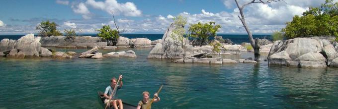
Mozambique is one of the most ancient countries in the world. People have lived here for more than 2 million years, the first fossil remains Homo sapiens were first discovered in this area. Various peoples, many of whom have now disappeared from the face of the Earth, have swept through this land in waves of migrations for at least 100,000 years. About 2,000 years ago, Bantu peoples began migrating into this area, bringing iron tools and weapons, and formed the basis modern population countries. The thriving trade in gold and ivory raised the civilization of Mozambique to one of the highest levels in Africa, and to this day the depths of the country conceal many mysteries and secrets of past eras. Tourists are attracted to the country mainly by its beautiful sandy beaches. The beautiful coastlines of Tofu, Moma, Langosche, Lurio and Cape Barra were legendary places until recently and are quickly regaining their former fame. The Tofu area is more accessible and more developed, with a hotel and a well-organized recreational structure that has suffered fairly little damage. Barra is somewhat more inaccessible, but quieter, and with somewhat better conditions: clean dunes with constant surf on one side and mangrove forests and palm groves on the other side of the cape, where flocks of almost tame parrots and monkeys are quite common. The capital of the country, Maputo, grew up on the site of a Portuguese fort founded in 1781, from which the ramparts, old guns and a grassy courtyard have been preserved. Almost no ancient buildings have survived in the city. Maputo was previously known as a very beautiful city and was rated by travelers on par with Cape Town and Rio de Janeiro, but after almost 20 years of war and deprivation, the capital was very dilapidated, with crumbling buildings and dirty streets. However it is still very interesting place, with a very lively atmosphere and friendly residents, slowly but surely regaining its former charm. Among the city's attractions are the Natural History Museum and the train station, designed and built at the beginning of the 20th century. the same Eiffel who created the famous tower in Paris. The newly renovated station looks more like a palace, topped by a giant copper dome with polished wood and marble decorations. Also interesting Botanical Gardens, the National Art Museum which has a wonderful collection of Mozambique's best contemporary artists and a vibrant Municipal Market selling a variety of fruits, vegetables, spices and traditional basketry from local artisans. Beira is 880 km away. north of Maputo, the second largest city in Mozambique, is the main port and terminus of the Trans-African Railway. Its compact central area and old Mediterranean-style buildings give the city a special charm. The heart of the city is the Praça (main square), which is surrounded by shops, markets and offices. Cathedral, lying to the southeast of the center, looks somewhat unkempt, but has definitely retained the former grandeur of its inner stop. The bustling market in Chunga Moyo ("brave heart") is full of imported goods and contraband. The coast near Praia de Macuti is called “beautiful sands” (and quite rightly). The entire coast of this area is rich in various cases of finds of shipwrecks from past centuries, especially many of them are thrown ashore by the surf near the “red” and “white” lighthouses at the northern end of the beach. Pemba, a coastal city at the throat of a large bay in the north of the country, can be proud of its interesting buildings , especially in Baixa - the old town, and the lively atmosphere of its streets. Most visitors come here for the gorgeous beaches, especially Wimby Beach (or Wimbe) and the coral reefs located so close to the shore that they can be easily reached by swimming. Wimby is 5 km away. east of the city. A rapidly recovering tourism industry is already transforming the area into a luxury resort with bars, restaurants, water entertainment centers and well-equipped facilities for diving, snorkeling, rowing, fishing, surfing and more. On the road between the town and the beach there is a Makonde craft workshop that makes beautiful wooden figurines for sale at very low prices. The Cathedral of 1563 in the city of Tete, 150 km away, is interesting. to the southeast down the Zambezi River, however, to visit it you must have permission from the authorities, which is due to the turbulent situation in the area. 500 km. to the northwest of the coast, the Zambezi River is dammed by the enormous Dam de Cajora Basso, built in the 1970s, one of the largest civil engineering projects in Africa. Lying in a stunning landscape at the neck of a magnificent gorge, the dam created the magnificent Lago de Cajora Bassa, 270 km away. long, stretching upstream to the confluence of the Zambezi and Luangwa rivers on the border with Zambia. The island of Ile de Mozambique (commonly called simply "Ile") is a small piece of land located 3 km. from the mainland and connected by a bridge, was previously the capital of the East African colony of Portugal. Il is now famous for its many mosques and churches and its Hindu temple. Most of the historical sites are located on the northern half of the island, which has been declared a UNESCO World Heritage Site. Attraction number one is the Palace and Chapel of Sao Paulo - the residence and residence of the former governor of the country, dating back to the 18th century. This building is a large area, paved with great taste with stones quarried here, on the western tip of the island. Today it is a museum that contains rare furniture and decorations from Portugal, Arabia, India and China, which are in remarkably good shape for such a turbulent history. Nearby is the Museum of Sacred Art, containing religious jewelry, paintings and sculpture. At the northern tip of the island is the medieval Fort San Sebastian, also in surprisingly good condition, and the Chapel of Nossa Senhora de Baluarte, the oldest building in the southern hemisphere. Mozambique has a rich artistic tradition that can seem incredible as it continues to thrive after decades of colonialism and civil war. Today Mozambique has one of the most distinctive and interesting forms of folk art in Africa. Makonde sculpture is recognized as one of Africa's most complex and sophisticated artistic forms. The traditions of fresco painting are also strong, the first examples of which were found during excavations of settlements more than 2 thousand years old. The largest and most famous of the modern frescoes is located near the capital's airport, is 95 m in length, and reflects the events of the Revolutionary period. Traditional music is very popular both in Mozambique and abroad; many researchers, not without reason, consider it one of the origins of “reggae” and new age. The “instruments of the wind” (“lupembe”) of the Makonde people in the north of the country are unique. In the south, musicians traditionally use the marimba, a type of xylophone that spread from this area throughout southern Africa. Mozambican marimba orchestras are widely known throughout the world, attracting full houses in the best concert halls on the planet. The "marrabenta" they perform is the most typical Mozambican music, with a light style and traditional rural rhythms. One of the most beautiful places on the continent - Marine National Park"Bazaruto Archipelago" 10 km. off the coast, with blue waters, sandy shores, palm trees, ancient coral reefs, plus a myriad of tropical fish inhabiting these waters. Scuba diving and excellent fishing are possible here. The entire area between the mainland and the 150 islands is now protected as a world-class nature reserve. If you stay in one of the dozens of luxury houses on the islands, it is quite possible to rent a speedboat for a mini-cruise around the archipelago. Also quite interesting National parks countries - Gorongosa, Banyine, Zinave, etc., which are quickly recovering and have a full range of natural attractions and unique wildlife.
Imagine a frozen ocean without a single wave, a huge moon illuminating everything around for kilometers, an endless deserted sandy beach, crowns of coconut palms and tens of thousands of sea crabs swarming in the shallows after low tide. These places are for nature lovers; there is no need for evening dresses like in Mauritius. But here it’s easy to find a place for solitude, go behind a sand dune and be alone with the ocean, sunbathe and swim. We won’t even talk about fishing, diving and Mozambican sea cuisine. Marlin, sailfish and local king prawns are unbeatable.
Geographical position: Mozambique is located in southeast Africa opposite the island of Madagascar. It borders on Tanzania in the north, South Africa and Swaziland in the south and southwest, and Zambia, Zimbabwe and Malawi in the west. In the east it is washed by the waters of the Mozambique Channel. Mozambique's territory extends along the Indian Ocean coast for approximately 3,000 km. The coastline in the north is dissected by small bays, the shores are low but rocky. To the south the banks are low and swampy in places. There are natural harbors: Beira, Maputo, Nacala, Pemba. Two-fifths of the country's territory is occupied by coastal plains. In the center of the country there are several plateaus, reaching a highest point of 2436 m (Mount Binga) near the western border. The Namuli mountain range in the north of the country rises to 2419 m. In the northeast lies the Angonia Plateau. In the northern, wider region lies the Mozambique Plateau, which descends in steps east to a narrow coastal lowland (up to 30 km wide). To the south, the lowland expands to 400 km, occupying a total of 44% of the entire area of the country. The total area of the country is 802 thousand square meters. km.
Capital: Maputo. The largest city in Mozambique, located in the south of the country, on the eastern shore of Maputo Bay, at the mouth of the Temb River. Large port on the Indian Ocean, economic life concentrated in the harbor area. The official population is about 1.3 million people, but in reality it is much higher than this figure due to the large number of slums and other illegal buildings.
Language: Portuguese (official language). English is also used for communication (especially in the capital). The most widely spoken local languages are Imakua, Chinyanja, Chishona and Shangaan.

Religion: According to the 1997 census, Mozambicans consider themselves to be of the following faiths: non-religious (possibly many in this group retain traditional beliefs) - 24.25%, Catholics - 24.2%, Muslims - 17.8%, non-Catholic Christians (mostly Protestants) – 11.45%; (Assemblies of God, Methodists, Anglicans, Nazarenes, Adventists), syncretic cults (a mixture of different religions, for example, combining elements of Christianity and traditional African beliefs) - 18.7%, others - 3.6%.
Time: The time difference in Mozambique is 2 hours (relative to time in Moscow). The entire territory of the country is in the same time zone. The country does not switch to summer/winter time, so the time difference remains the same throughout the year.
Climate: The climate of Mozambique in the north is close to equatorial (+25-28 C, precipitation 1300-1500 mm per year), in the south it is tropical trade wind (+20-22 C, precipitation 500-1000 mm per year). The wet season lasts from November to April-May. Droughts and destructive tropical cyclones are frequent. The best time to visit the country is from May to November, during the cooler and less rainy winter months. You can travel during the rainy season, but closer to March, some roads are severely washed out, especially in the center and south of the country. People come to Mozambique to watch wild animals in August-September, and to watch birds from December to April.
Currency: Metical (MZN) equal to 100 centavos. In circulation there are banknotes in denominations of 20, 50, 100, 200, 500 and 1000 meticals, as well as coins in 1, 5, 10, 20 and 50 centavos and 1, 2, 5 and 10 meticals. $1 is equal to approximately 30 meticals. It is better to change money at private exchange offices in Maputo (better rate) or in banks (safer, high commission). You should immediately forget about exchanging money on the street - it is extremely unsafe. The use of credit cards and traveler's checks is difficult throughout the country, and in the provinces it is completely impossible. Bank opening hours: Mon-Fri 7:30-11:15 and 15:00-16:30. Almost all shops and souvenir shops happily accept not only the national currency, but also US dollars and South African rands (they are especially loved in the south).
Mains voltage and socket type: 220/240 V, frequency alternating current- 50 Hz; Plug sockets usually have two sockets (European type, no adapter is needed), but there may also be three sockets (an adapter for Russian plugs is required).

Customs: The import of foreign currency into Mozambique is not limited (a declaration is required for amounts over 5 thousand US dollars). The import and export of national currency is prohibited. Duty-free import is allowed: cigarettes - up to 400 pcs., or cigars - 50 pcs., or tobacco - 250 g, wine - up to 5 liters, spirits - up to 1 liter, perfumes and medicines - within the limits of personal needs, new goods on an amount not exceeding 100 US dollars. It is prohibited to import drugs, weapons and ammunition for them, pyrotechnics, gold, platinum and silver in bars, plates or coins without the permission of the country's bank, handicraft alcoholic beverages, as well as photographs, graphics, printed materials and video materials "obscene or directed against the Republic of Mozambique or the dignity of the Mozambican people."
The export of ivory and ivory products, food products is prohibited unless the conditions for their storage along the route are ensured.
Population and culture: The population of Mozambique in 2007 was 20,366,795. The country's population is unevenly distributed. Most of the population lives in the coastal areas, along the Zambezi River and on the Angonia Plateau. 98% of the population of Mozambique are people of the Bantu language family. The most numerous people are the Makua people (more than 50%), living in the north of the country. In the south, on the border with South Africa, Tsonga are settled (about 25%). Along Lake Nyasa live Malawi (about 13%) and Yao (more than 3%), in the center are the Shona (about 6%), and in the northeast are the Makonde. There are also Swahili and Zulu, who are much smaller in number. The country is home to people from Asia (Indians make up 0.08% of the population), as well as mulattoes. The number of people of European nationality fell sharply (from 2% to 0.06%) after Mozambique gained independence. Ethnic composition: blacks 99.66%, mulattoes 0.2%, Indians 0.08%, whites 0.06%.

Because of large number different ethnic groups living in the country, the culture of Mozambique has developed over time into a very rich and diverse one. Many rituals, customs, and traditions of the people of Mozambique originated from different tribes and religions. Traditionally, the people of Mozambique believed in animism, so the country practices corresponding animist rituals. Wood carving and sculpture making are the two main traditional forms art in Mozambique. They are especially practiced among the Makonde peoples. Another popular art form is the making of masks called "family trees". Music and dancing are part of the rituals of the peoples of the country. In particular, animistic rituals are accompanied by music and dance. Portuguese music has left a strong mark on the country's folk music. A very popular musical form is marrabenta, which is basically dance music.
Kitchen: The Portuguese left their mark not only on the culture and religion of the country, but also on national cuisine Mozambique. Mixed with traditional African dishes, it is quite a mouth-watering and tempting mixture, especially on the fish menu. It is worth trying Piri-Piri sauce - the African equivalent of the hottest chili. Paozinho - pork or beef rolls served with semi-sweet bread. Matapa is a fish dish, usually crab or shrimp, cooked with Casave leaves and rice. Camarao National shrimp are marinated in piri-piri sauce, garlic, onion, lemon and vinegar. And finally, Kakana is a local vegetable with a bitter taste. Another local dish is goulash, which consists of broken up dried fish, fried in oil and mixed with chicken, potatoes, onions, chili and water.
Popular local beers include 2M (pronounced doish-uh), Laurentina Clara and Manica, as well as beers from neighboring African countries: Castle or Windhoek. Strong alcohol, like gin or vodka, is inexpensive and sold everywhere. You can try the local vodka cashu, which is made from cashews, has a sour taste and is said to be good for male libido.

Tips: In Mozambique, it is customary to tip about 10% of the total order in a restaurant. Porters are given a tip of about 0.5 USD per piece of luggage; the driver or guide: 1-2 USD per day.
Souvenirs: At local markets you can buy all kinds of crafts: female and male figurines and sculptural groups made from a single piece of wood, ritual staffs with anthropomorphic heads, spoons decorated with ornamental carvings and human figurines, elegant clay vessels with a white ornament in the form of a zigzag ribbon, smoking pipes , mitete - boxes for medicinal potions and tobacco with stylized drawings on the lid and mortars with carved figures of a person, intended for grinding potions. Also interesting are the wooden carved headrests of the Karanga and the famous ceramics of the Shona people - huge vessels for storing water or grain, covered with pieces of clay and reminiscent of boulder stones. In Mozambique, everything that does not have a price tag is negotiable. It is also worth keeping in mind that, with the exception of large shops and hotels, no one will give a tourist change for a banknote of 500 MZN or higher. So it’s worth exchanging small money in banks or exchange offices in advance.

Air travel: Most international flights to Mozambique connect at Johannesburg Airport (South Africa), although there are direct flights from Maputo to Swaziland and Zimbabwe, as well as to Tanzania, Kenya and Portugal. For example, Kenya Airways, Swazi Express Airways and TAP Portugal fly directly to Maputo from Durban, Swaziland, Dar es Salaam, Harare, Nairobi and Lisbon. The most convenient way for Russians to get here is by flying Qatar Airways (via Doha) or Lufthansa (via Frankfurt) to Johannesburg, and from there by flying South African Airways or Linhas Aereas de Mocambique to Maputo. South African Airways and Linhas Aereas de Mocambique fly to Pemba several times a day from Johannesburg, Dar es Salaam and Nairobi.
Mozambique on the map of Africa
(all pictures are clickable)


On the map of Africa, Mozambique is hard to miss - it ranks 16th in the territorial ranking ( total area- 801.6 thousand km²). The country shares land borders with Tanzania, Zambia, Malawi (in the north and northwest), Zimbabwe (in the west), South Africa and tiny Swaziland (in the south). The entire eastern border (about three thousand kilometers) is the coast of the Indian Ocean.
Geographical position
Extended coastline with a large number of natural harbors is one of the main geographical advantages of Mozambique. The southern part of the state is continuous lowlands, swampy in places, but above the Zambezi River moderately high plateaus and hilly plains with small inclusions of mountain ranges prevail.
Not all of East Africa can boast such reserves fresh water, like Mozambique. Six rivers flow through its territory (from the west towards the ocean). large rivers, and on the border with Malawi (in the northwestern part of the country) is Lake Nyasa.
The state is located in two climatic regions: subequatorial and tropical. The temperature is quite stable throughout the year: in the southern lowlands - from +25 to +30 °C, in the area of the northern plateaus it is five degrees cooler.
The amount of precipitation depends on the season: from November to May, catastrophically powerful cyclones often hit the coast; in winter (from June to October) there is practically no rain. At this time, Mozambique (like other African countries) may suffer from total drought.
Flora and fauna
In the south of the country, savannas predominate, to the north of the Zambezi - tropical and mountain forests, as well as miombo - a special deciduous woodland. On the coast there are areas of mangroves, and river beds are covered with a thick canopy of vines. Here you can find ebony, red and iron wood, date palms.
The abundance of suitable habitat attracts a wide variety of birds and animals. National parks have been created throughout the country, where rhinoceroses, giraffes, hippos, elephants, zebras, and leopards are found. In the savannah, lions hunt ungulates; monkeys and lemurs thrive in the forests. The coastal waters are home to amazing sawfish.
State structure

Mozambique Map
The Republic of Mozambique is led by a popularly elected president. The local unicameral parliament is represented mainly by two parties with real political weight.
The country is officially divided into eleven districts, each headed by a governor appointed by the president. The capital and largest city is Maputo, which arose on the site of a trading post founded by the Portuguese back in the 18th century.
Population
If at the end of the 20th century, according to the census, there were 15 million citizens in the country, today more than 25 million people live here. The reason is the high birth rate (for this indicator Mozambique ranks twelfth in the world). At the same time, life expectancy is short (on average about 52 years).
The vast majority of Mozambican citizens are descendants of ancient aborigines. People from Asia and Europe make up less than one percent. Official language- Portuguese, but the majority of the population uses one of the local dialects in everyday life.
The state is extremely tolerant of issues of faith: the number of Catholics, Muslims, Protestants, atheists and followers of various national cults is approximately the same.
Economy
Despite the deposits of in-demand minerals (iron ore, gas, coal, non-ferrous metals, titanium), the state remains agrarian - about 80% of local residents work in the agricultural sector. The main income comes from the export of timber, seafood, cashews, sugar, cotton, and citrus fruits.
At the same time, the country has a well-developed infrastructure: big cities connected by local airlines, there is a network railways. Tourism is actively developing. Recently, foreign companies are more willing to invest in state economy, which, according to experts, came out of depression.
Mozambique, which was a Portuguese colony for several centuries, gained real independence only in 1975. Subsequently, a series of ill-conceived and unpopular reforms led to the collapse of the economy, mass emigration and many years of civil war with a huge number of human casualties(peace was achieved only in 1992). Today the confrontation between the leading political parties is preserved, but it happens in a civilized manner - through electoral struggle.
Attractions
National parks and luxurious beaches are the main attractions of the state. In Maputo, tourists enjoy visiting the Natural History Museum, and in Beira they go to stroll through the markets and small handicraft shops. Travelers are advised to visit the tiny island of Ile de Mozambique with its unique ancient architecture.
Mozambique photo