Sections: Geography
Methods and forms of educational activities:
Goals and objectives of the lesson:
- Study the main features of the geographical location of the Altai Territory.
- Introduce the concept of geographical local history as an integral part of geography.
- Develop skills and abilities to characterize a geographical location. Develop skills and abilities to work with maps and tables.
- Strengthen the skills of schoolchildren to calculate geographic coordinates.
- To promote the formation of skills to independently apply previously acquired theoretical knowledge.
- Cultivate feelings of love for native land and pride in her.
Basic knowledge and skills. The concept of “geographical location”, features of the geographical location of Russia, the ability to determine the geographical coordinates of objects on a map and calculate the distance in degrees and kilometers along parallels and meridians.
Practical work: Definition geographical coordinates extreme points of the edge and extent from north to south and from west to east in degrees and kilometers. Drawing on a contour map the extreme points of the edge, edge boundaries, and district boundaries. Designation of neighboring territories.
Equipment: political and administrative map of Russia, physical map Altai Territory, atlas of the Altai Territory, photographs with views of natural objects of the region.
Lesson plan:
- Characteristics of geographical edge position, borders of the Altai Territory.
- Administrative-territorial division of the region.
- Practical work No. 1. Filling out contour maps.
- Lesson summary.
During the classes
I. Organizational moment.
II. Studying a new topic.
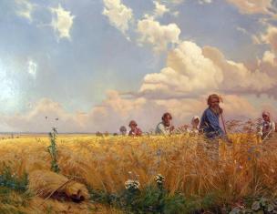
1.Opening speech by the teacher. Photos with views of the nature of the Altai Territory. (Annex 1)
"I love and I know. I know and I love.
And the more I love you, the better I know.”
Yuri Konstantinovich Efremov.
"Our nature is a storehouse of wealth and beauty.
In this pantry Altai is a special expensive box."
V. Peskov.
“Are we in Siberia? One can hardly believe this charm. The most wonderful climate, the most pleasant location, watered by the majestic, proud, calm Ob. This region is one of the most blessed not only in Siberia, but in all of Russia.”
This is what M.M. wrote in a letter to his daughter. Speransky - Governor General of Siberia, while in Barnaul in August 1820.
“A huge, beautiful land with the sunny name of Altai, which combines the experience and wisdom of many peoples and cultures. This is a land of courageous people and fantastic opportunities, which means it is simply doomed to prosperity.”
A.A. Surikov.
The Altai Territory was formed on September 28, 1937. In 1991, the Gorno-Altai Republic separated from its composition (since 1992 - the Altai Republic). Our region - Altai Territory - is located in the center of the largest continent on Earth - Eurasia. The name “Altai” itself comes from the Turkic-Mongolian dialect and means “Golden Mountains”. The Altai land is beautiful, its landscapes, vegetation, and fauna are diverse, the region is rich in minerals, monuments of nature and human history.
But there is a wonderful corner in the very south of the Altai Territory, where, as if to surprise, a multitude of unique beauties are collected. The Altai region is located in the center of the largest continent on Earth - Eurasia. Within its borders are the southeastern edge of the West Siberian Plain and the highest and most significant part of the Altai mountain region.
The traveler will find here the mirror-like surface of emerald lakes and vast expanses of now plowed steppes, birch copses pleasing to the eye, forests of pine, larch, and cedar. A dense network of rivers cut through our lands.
Large reserves natural resources, Altai grain field, developed economy - the basis of the well-deserved glory and fame of the region. From the vastness of Altai, cosmonauts and writers, noble landowners and gardeners, artists, doctors, and teachers emerged into big life. During the difficult years of the war, our fellow countrymen stood shoulder to shoulder in battle formation and bravely defended their homeland from enemy hordes.
Altai is an important economic region of Russia with diverse agriculture and a large diversified industry.
Altai - birch groves with cuckoo tears in the vicinity of their native village, mysterious tracts with wolf tracks, groves with thickets of bird cherry and viburnum, strawberry meadows, winding rivers, beaver huts along their banks, the smells of taiga and meadow grasses.
A lot of scenic spots in Altai - Lake Teletskoye and the Karakol lakes, the Chuysky tract and the wayward Katun River, mountain gorges and Belukha covered with glaciers:
This is an untold country - the Altai Mountains. Pristine and untouched nature, harsh climate and places where Almaty apples grow and bear fruit, majestic mountains and clear lakes, stormy mountain rivers and alpine meadows. And blue - blue in dozens of shades. The amazingly beautiful nature of the Altai Mountains. Probably, this surprise is why tourists go to the mountains, sail along stormy rivers on rafts and catamarans, climb steep cliffs and descend into narrow mountains of caves.
Altai is also famous for its ancient history, its revolutionary, military and labor traditions. Here the partisans heroically fought against the Kolchakites during the civil war, and the first communes were created on Altai soil. During the Great Patriotic War, thousands of Altai residents fought on the fronts, and in the rear its wonderful workers brought victory closer.
Now Altai is a major tourist area that attracts thousands of travelers every year. Many people come from abroad to see with their own eyes all this beauty, which cannot be described in words, conveyed in gestures, or captured in photographs. It needs to be seen, it needs to be felt and experienced. Interest in Altai is growing every year. The region has a great tourism future.
2. Characteristics of the geographical location of the region.
- Introduction of the concept of “geographical local history” (Appendix 2).
- A conversation about what the Altai Territory looks like on a map of the country, what its size is. (Appendix 3).
- Features of the geographical location of the region (analysis of the political and administrative map of the Altai Territory, Appendix 4 and 5):
a) comparison by area with other states
b) length from north to south, from west to east, length of the border, types of borders (working with the atlas of the Altai Territory, writing in a notebook)
c) border territories (working with the atlas)
d) positive and negative traits EGP of the region (working with a table).
Table No. 1
Assessment of the EGP of the Altai Territory
3. Administrative and territorial division of the region (working with the political and administrative map of the Altai Territory).
Determine how many districts are included in the region?
Find the area where you live on the map.
Which regions of the Altai Territory does the Pavlovsky District border with?
Which natural and economic district of the Altai Territory does Pavlovsky District belong to?
Name and show on the map the cities of the Altai Territory?
III. Consolidation.
1. Discounts with maps and atlases. Conversation. [Map of the Altai Territory, Pavlovsky district on the map of the Altai Territory]
- find the Altai Territory on the map of Russia;
- name and show on the map with which entities Russian Federation borders the Altai region;
- determine the distance to the nearest sea;
2. Practical work. While explaining new material, students simultaneously do work on contour map Altai Territory (Appendix 6).
Task 1. Circle the borders of the Altai Territory in red.
Task 2. Mark the extreme points with an asterisk, determine and label their geographical coordinates.
Sign the names of the border regions of the Russian Federation and the independent states with which our region borders.
Task 4. Determine the length in degrees and kilometers from north to south, from west to east.
Greatest length:
- from north to south about 500 km.
- from west to east about 560 km.
To test your mastery of new material, you can ask them to answer test questions.
Geography of the region
1. What does the word "Altai" mean? (The word "Altai" is of Mongolian origin, meaning "gold-bearing").
2. What is the area of the Altai Territory? (167.85 thousand square km).
3. Name the capital of the Altai Territory. (Barnaul).
4. How many cities are there in the Altai Territory? (12 - Barnaul, Biysk, Novoaltaisk, Rubtsovsk, Belokurikha, Slavgorod, Kamen-on-Obi, Zarinsk, Aleysk, Yarovoye, Zmeinogorsk, Gornyak).
5. How many administrative districts are there in the Altai Territory? (60).
6. What is the population of the Altai Territory. (2562 thousand people - 2003).
7. Name the border areas. (Novosibirsk, Kemerovo regions; Kazakhstan: Pavlodar, Semipalatinsk, East Kazakhstan regions, Altai Republic).
8. Which states can be located on the territory of the Altai Territory taken together? (Austria, Belgium, Denmark, Portugal).
9. Name the health resorts of the Altai Territory that are of national importance? (Belokurikha, Yarovoye).
10. What is the approximate length of the city of Biysk along the Biya and Ob rivers? (40 km).
11. Name the confluence of three large rivers of the Altai Territory? (c. Odintsovka).
12. Name the rivers of the Altai Territory that do not flow into the ocean? (R. Kulunda, R. Burla).
13. What are the largest lakes in our region? (Kulundinskoye, Kuchukskoye, Gorkoye).
14. On which rivers of the Altai Territory is water tourism carried out? (Peschanka river, Biya river, Katun river).
15. An All-Russian tourist and entertainment complex will be created in the Altai Territory. In what area and in what village will it be built? (c. Solonovka - Smolensk district).
IV. Bottom line. Conclusions.
- Guys, what new did you learn in today's lesson? (Students' answers)
- Show on the map which objects were mentioned in the lesson? (Students show geographical objects).
V. Homework.
Repeat educational material. Prepare a description of the geographical location of the Pavlovsk region.
Goal of the work: formation of skills to determine the geographical position of mountains, plains and their heights; development of skills to determine geographic coordinates.
Task 1. Compare the geographical location of objects and fill out table 8.
Table 8.
Geolocation Plan Geographical feature (mountains, plains) Ural Mountains West Siberian Plain 1. On what continent and in what part of it is it located? Eurasia, Russia Eurasia, Russia 2. Position in relation to other geographic objects in the West of the West Siberian Plain in the East of Ural mountains 3. Direction and extent length 2200 km, S-NE 4. Medium height 800 m 100 m 5. Geographic coordinates of the highest points Narodnaya 1895 m, 65 N 60 east -
Task 2. Using atlas maps, characterize the indicated landforms and fill out table 9.
Table 9.
Name of mountains, plains The position of mountains and plains in relation to other geographical features Direction and extent Geographic coordinates and absolute heights of mountain peaks and hills Caucasus SW Elbrus 5642 m
43 N, 42 E
Altai on South Belukha 4506
50 N, 85 E
Ural Mountains in the east from the Caucasus and the East European Plain, in the west from Altai, the West Siberian Plain and the Central Siberian Plateau Narodnaya 1895
65 N, 60 E
the East European Plain to the NE of the Caucasus, to the west of the rest 1200 m Khibiny
68 N, 33 E
West Siberian Plain in the east of the Ural Mountains and the East European Plain. To the northeast of the Caucasus, to the west of the Central Siberian Plateau, to the northwest of Altai - Central Siberian Plateau in the east - NE Plutorana plateau 1701 m
69 N, 96 E
Altai Territory is located in the south Western Siberia. The average length of the territory from north to south is 360 km, from west to east - 585 km. It borders: in the south and southeast - with Kazakhstan, in the southwest - with the Altai Republic, in the west and northwest - with the Kemerovo region, in the north - with the Novosibirsk region.
The territory of the region belongs to two physical countries - the West Siberian Plain and the Altai-Sayan Mountains. The mountainous part covers the plain on the eastern and southern sides - the Salair Ridge and the foothills of Altai. The western and central parts are predominantly flat in nature - the Ob Plateau, the Biysk-Chumysh Upland, and the Kulundinskaya steppe. The region contains almost all natural zones of Russia - steppe and forest-steppe, taiga and mountains. The flat part of the region is characterized by the development of steppe and forest-steppe natural areas, with ribbon pine forests, a developed girder-gully network, lakes and ridges. The highest point - 2490 meters - does not yet have official name on the map and is located at the source of the Kumir River on the Korgon ridge.
The water resources of the Altai Territory are represented by surface and groundwater. Most large rivers(out of 17 thousand) - Ob, Biya, Katun, Chumysh, Alei and Charysh. Of the 13 thousand lakes, the largest is Kulunda Lake, its area is 728 square meters. km. The main water artery of the region is the Ob River, 493 km long within the region, formed from the confluence of the Biya and Katun rivers. The Ob basin occupies 70% of the region's territory.
Plants. Of the 3,000 species of plants growing in Western Siberia, in the Altai Territory there are 1,954 species of higher vascular plants belonging to 112 families and 617 genera. The flora of the region includes 32 relict species. These are Siberian linden, European hooffoot, fragrant bedstraw, giant fescue, Siberian brunnera, floating salvinia, water chestnut and others. Of the almost 2000 species of vascular plants found in the Altai Territory, 144 species are included in the Red Book. These are rare species, endemic, reducing their range, and also relict. Species richness flora region is due to the diversity of natural and climatic conditions.
According to preliminary estimates, the region is characterized by more than 100 species of lichens, 80 species of bryophytes, and about 50 species of macromycete fungi. Among these objects there are also rare ones listed in the Red Book of Russia.
The region is home to about 100 species of mammals, more than 320 species of birds, 7 species of reptiles, 6 species of invertebrate animals. Mammals are represented mainly by insectivores and rodents (eared hedgehogs, jerboas) and bats (there are 9 species, including the pointed-eared bat, listed in the Red Book of Russia). Two representatives of the mustelid family entered here - an otter and a bandage.
ALTAI (from the Turkic-Mongolian “altan” - golden), a mountain system in Asia, southern Siberia and Central Asia, on the territory of Russia (Altai Republic, Tyva Republic, Altai Territory), Mongolia, Kazakhstan and China.
It stretches in latitude from 81 to 106° east longitude, in longitude - from 42 to 52° north latitude. It extends from northwest to southeast for more than 2000 km. Consists of high mountain ( highest point- Mount Belukha, 4506 m) and mid-mountain ridges and intermountain basins separating them.
In the north and north-west it borders with the West Siberian Plain, in the north-east - with the Western Sayan and the mountains of Southern Tuva, in the east - with the Valley of the Great Lakes, in the south-east - with the Gobi Desert, in the south - with the Dzungarian Plain, in the west The valley of the Irtysh River is separated from the Kazakh small hills. Altai is the watershed between the Arctic Ocean basin and the drainless region of Central Asia.
Orographically, the Gobi Altai, Mongolian Altai and Altai proper, or Russian Altai, are distinguished. The latter is often identified with the concept of “Altai” and is part of the sublatitudinal mountainous country of Southern Siberia, forming the western end with a latitude length of over 400 km, from north to south - about 300 km (see map).
Advertising
 Relief.
The relief of the Russian Altai was formed as a result of the long-term impact of exogenous processes on the growing uplift and is characterized by great variety forms Most of the northwestern or sublatitudinal ridges form a fan diverging in a westerly direction.
The exception is the ridges of the northern submeridional orientation and the southern periphery. There are a number of vast plateaus (Ukok, etc.), highlands (Chulyshman, etc.) and mountain ranges (Mongun-Taiga, etc.), as well as large intermountain basins occupied by steppes (Chuyskaya, Kuraiskaya, Uimonskaya, Abayskaya, Kanskaya, etc. .).
High mountain ranges and massifs are located mainly in the east and southeast. The following ridges rise above 4000 m: Katunsky (height up to 4506 m), Sailyugem (up to 3499 m), Severo-Chuysky (up to 4177 m). The following ridges are significant in height: South Chuysky (height up to 3936 m), Southern Altai (up to 3483 m), Chikhacheva (up to 4029 m), Tsagan-Shibetu (up to 3496 m) and Shapshalsky (up to 3608 m). The isolated Mongun-Taiga massif (3970 m) is distinguished by its high mountainous terrain.
The highlands are characterized by peaked ridges, steep (20-50° or more) slopes and wide valley bottoms filled with moraine or occupied by glaciers. Landslide-talus slopes, formed by intense gravitational processes, are widely developed. Glacial landforms are widespread: cirques, glacial cirques, troughs, carlings, moraine ridges and ridges. Mid-mountain and low-mountain ranges are located mainly in the west and north of Altai.
Among them, the most significant are: Terektinsky (height up to 2926 m), Aigulaksky (up to 2752 m), Iolgo (up to 2618 m), Listvyaga (up to 2577 m), Narymsky (up to 2533 m) and Baschelaksky (up to 2423 m) ridges.
In the middle mountains, alpine relief features are found fragmentarily. Wide, massive interfluves with flattened and plateau-like peaks predominate, where cryogenic processes are developed, leading to the formation of kurums and altiplanation. There are karst landforms. River valleys are often narrow, steeply sloped gorges and canyons 500-1000 meters deep. The peripheral lowlands of Altai are characterized by a relatively shallow depth of dissection (up to 500 m) and gentle slopes. The valleys are wide, flat-bottomed, with a well-defined complex of terraces.
Fragments of ancient leveling surfaces have been preserved on the flat tops. The bottoms of the basins are occupied by sloping plains of proluvial origin and moraine amphitheaters bordering the ends of trough valleys. In the east of Altai, the bottoms of basins are complicated by thermokarst forms.
 Geological structure and minerals.
Altai is located within the Paleozoic Altai-Sayan folded region of the Ural-Okhotsk mobile belt; is a complex folded system formed by Precambrian and Paleozoic strata, intensively dislocated during the Caledonian era of tectogenesis and the Hercynian era of tectogenesis. In post-Paleozoic times, folded mountain structures were destroyed and turned into a denudation plain (peneplain).
Based on the characteristics of the geological structure and the age of final folding, they distinguish between the Caledonian Mountain Altai in the north-west (occupies about 4/5 of the entire territory) and the Hercynian Rudny Altai in the south-west and south. The anticlinoria of the Altai Mountains (Kholzun-Chuisky, Talitsky, etc.) are mainly composed of flyschoid terrigenous series of the Upper Cambrian - Lower Ordovician, overlying Vendian-Lower Cambrian ophiolites, siliceous-shale formations and presumably Precambrian metamorphites, in places protruding to the surface.
The superimposed depressions and grabens (the largest is the Korgonsky) are filled with molasse of the Middle Ordovician - Lower Silurian and early Devonian. The deposits are intruded by Late Devonian granites. Within the Rudny Altai, which has a Caledonian basement, rocks of the volcanoplutonic association of the Middle Devonian - Early Carboniferous and Late Paleozoic granitoids are widespread.
In Oligocene-Quaternary times, Altai experienced an uplift associated with regional compression of the earth's crust caused by the convergence of the lithospheric microplates that bound it (Dzhungar, Tuva-Mongolian).
The formation of the mountain structure took place according to the type of large vault, which last stages development was deformed by a system of discontinuities, as a result of which a series of block morphostructures in the form of high ridges and depressions separating them were formed in the central and southern parts. Instrumental observations record vertical movements of the earth's crust, the speed of which reaches several centimeters per year. Uplifts occur unevenly and are accompanied by thrusts, which causes the asymmetry of the ridges.
Altai is one of the most seismically active inland regions of the world.
One of the largest seismic disasters (9-10 points) occurred in the high-mountainous Kosh-Agach region on September 27, 2003. Traces of ancient disasters (paleoseismic dislocations) are known.
The main wealth of the subsoil of Altai consists of deposits of precious metals and pyrite lead-zinc-copper-barite ores (Korbalikhinskoye, Zyryanovskoye, etc.), forming the polymetallic belt of Rudny Altai. In the Altai Mountains there are deposits of mercury, gold, iron, tungsten-molybdenum ores.
Deposits of ornamental stones and marble have long been known. There are thermal mineral springs: Abakansky Arzhan, Belokurikha, etc. The climate of Altai is continental in the foothills, sharply continental in the inner and eastern parts, which is determined by its position in temperate latitudes and a significant distance from the oceans.
Winter is harsh and long (from 5 months in the foothills to 10 months in the highlands), which is facilitated by the influence of the Asian anticyclone. The average January temperature is (in the foothills) from -15 to -20°C; in the northeast it is slightly higher and on the shores of Lake Teletskoye it reaches -9.2°C; in basins where temperature inversions are common, it drops to -31.7°C.
The recorded minimum temperature is -60°C (in the Chui steppe). Strong cooling is associated with the widespread development of permafrost, the thickness of which in some places reaches several hundred meters. Summer is relatively short (up to 4 months), but warm. The average July temperature ranges from 22°C (in the foothills) to 6°C in the highlands; in the basins and southern foothills a rise to 35-40°C or more is possible.
For mid-mountain and low-mountain areas, values of 14-18°C are typical. The frost-free period at an altitude of up to 1000 meters does not exceed 90 days, above 2000 m it is practically absent. Precipitation is associated mainly with western moisture-carrying flows and is distributed extremely unevenly over the territory and over the seasons. There is a clearly expressed exposure asymmetry, in which the windward slopes of the ridges, especially the western periphery, receive significantly more precipitation than the internal basins.
Thus, in the highlands of the Katunsky and South Chuysky ranges, up to 2000 mm of precipitation or more falls per year, while the Kurai and Chuyskaya steppes are among the driest places in Russia (up to 100 mm of precipitation per year). The lack of moisture in the basins is also explained by the drying effect of mountain-valley winds - hair dryers, especially in winter and autumn.
In low and mid-mountain areas, an average of 700-900 mm of precipitation falls per year. Maximum precipitation occurs in summer. The thickness of the snow cover in the northern and western regions and in the highlands reaches 60-90 cm or more, in the basins - less than 10 cm, and in years with little snow, practically no stable cover is formed.
There are over 1,500 glaciers known in the Altai Mountains with a total area of about 910 km2. They are most common in the Katunsky, South and North Chuysky ridges. The largest glaciers include Taldurinsky, Aktru (Akturu) and Maashey (Mashey), whose length is 7-12 km.

Katun River.

Altai. Lake Teletskoe.
Rivers and lakes. Altai is dissected by a dense network (several tens of thousands) of mountain rivers, according to their feeding regime they belong to the Altai type: they are fed by melted snow waters and summer rains; characterized by long spring floods.
Most of the rivers belong to the Ob basin, both of its sources - Katun and Biya - are located in Altai and are its main waterways. The western spurs are drained by the right tributaries of the Irtysh River, among which the Bukhtarma River stands out. The rivers of the northeastern part of Altai (Abakan and others) flow into the valley of the Yenisei River, the southeastern outskirts belong to the drainless region of Central Asia.
The total number of lakes in Altai is over 7000, with a total area of over 1000 km2; the largest are Markakol and Lake Teletskoye. Many small (usually 1-3 km2 or less) ancient glacial lakes often fill picturesque deep trough valleys.
In the north of Altai there are karst lakes.
Types of landscapes. In Altai, the altitudinal zonation of landscapes is well defined. In the lower landscape zone there are steppes, in the north there are mainly meadows, with areas of forest-steppes. In the south, the steppes form a wide belt, rising to a height of 1000 meters or more, and in some places they have desert features, turning into semi-deserts.
The most common mountain-steppe animals are gophers, voles, hamsters, and badgers; Birds include the steppe eagle, coccyx, and kestrel. The appearance of the steppes in the intermountain basins is similar. There are gazelle antelope, Mongolian marmot, manul cat, etc. In the steppe low mountains, leached and podzolized chernozems are developed, and in the depressions there are peculiar dry-steppe chestnut and dark chestnut soils.
The minor forest-steppe zone is associated with an exposure asymmetry of moisture and lighting, when larch (less often birch, aspen or pine) grows on the northern slopes of the low mountains, and meadow steppes grow on the southern slopes.
The forest belt predominates in the Altai Mountains. Mountain taiga forests dominate here: dark coniferous, the so-called black taiga of fir, spruce and Siberian pine (or “cedar”), and light coniferous of larch and Scots pine.
Among the inhabitants of mountain forests, taiga animals are typical - bear, lynx, weasel, squirrel, musk deer, deer, etc.; Birds include wood grouse, hazel grouse, nutcracker, woodpeckers, and crossbills. Black taiga on humus-rich deep podzolic or brown forest soils is widespread in the western foothills and the northeast.
Fir forests gravitate to the middle part of the mountain slopes, cedar taiga - to the upper parts. In dark coniferous forests, the herbaceous layer consists of large-grass and tall-grass species; the undergrowth is often absent or consists of ground cover (mosses, lichens), to which are added shrub and subshrub layers. Larch forests occupy significant areas in the basin of the middle reaches of the Katun River, on the Terektinsky and Kuraisky ridges. Pine forests, often park-type, are distributed mainly along the valleys of the Katun and Chulyshman rivers.
In light coniferous forests, the herb and shrub layer is diverse. Gray forest soils above 1700 m turn into forest-tundra and mountain-tundra. The upper limit of the forest in height ranges from 1600 to 2400 m; sparse taiga grows here with well-developed tall grass, shrub and grass-shrub layers. Higher up there are cedar and larch woodlands, alternating with thickets of shrubs (erniks) and subalpine meadows.
The dominant shrubs are round-leaved birch, willows, juniper, and Kuril tea. There are many tall grass meadows valuable species: maral root, Lobel's hellebore, blueberry, bergenia, etc. Alpine meadows, common in the highlands of the western and central regions of Altai, alternate with patches of moss-lichen cover or rocky placers. Formations of large-grass, small-grass, grass-sedge and cobresia meadows are distinguished.
The highlands also feature landscapes of subalpine meadows, mountain tundras, rocks, rocky outcrops, glaciers and eternal snow. Most of the highlands are occupied by mountain tundras, which are not distinguished by a large variety of species. There are meadow, moss-lichen, shrub and rocky tundras. Above 3000 meters there is a nival-glacial belt.
Among the animals of the high mountain zone, the Altai pika, mountain goat, snow leopard, and reindeer are typical. A special type of intrazonal landscapes of Altai are represented by swamps, widespread almost everywhere on flat interfluves and plateaus.
Specially protected natural areas. 5 sites of Altai (Altai Nature Reserve, protective zone around Lake Teletskoye, Katunsky Nature Reserve, Belukha Natural Park and Ukok Quiet Zone), called the Golden Mountains of Altai, have been included in the World Heritage List since 1998.
Natural landscapes and individual natural monuments are also protected in the Markakolsky Nature Reserve. A number of nature reserves have been created.
About the economy of Altai, see the articles Altai Territory, Altai (Altai Republic) and Tuva.
History of discovery and research.
General characteristics of the Altai relief
First Scientific research The nature of Altai dates back to the 1st half of the 18th century, when ore deposits were discovered in the west and the first copper smelters were built. Russian settlers, mostly runaway factory and state peasants, appeared in the north of Altai in the mid-18th century. The first Russian settlements, including Old Believer settlements, began to emerge in the 1750-70s, mainly along the valleys of the middle reaches of rivers. In the 19th century, the upper reaches of the rivers began to be settled, mainly by Kazakh nomads from China and Kazakhstan.
In 1826, K. F. Ledebur studied the flora of Altai. In 1828, placer gold deposits were discovered. In the 1st half of the 19th century, geological research was carried out by P. A. Chikhachev (1842), G. E. Shchurovsky (1844) and engineers of the mining department. In the 2nd half of the 19th century, numerous expeditions worked in Altai, including Russian ones geographical societies, Academy of Sciences, which included V.A. Obruchev, V.V. Sapozhnikov, who studied modern glaciation and vegetation cover of Altai for a number of years.
Beginning in the 1920s, a systematic study of the nature of Altai was carried out: large-scale topography and geological surveys, as well as the study of a variety of natural resources in connection with the development of mining, hydropower and agriculture.
Lit.: Kuminova A.
B. Vegetation cover of Altai. Novosibirsk, 1960; Mikhailov N.I. Mountains of Southern Siberia. M., 1961; Gvozdetsky N.A., Golubchikov Yu.N. Mountains. M., 1987.
S. A. Bulanov.
Geographical location of Altai
The Altai Republic is located at the intersection of two main regions: Western Siberia and Central Asia, which is located almost in the center of the Russian Federation, and also borders three neighboring countries: Mongolia in the south and China in southwest Kazakhstan. This situation determines the economic and climatic conditions in the region.
Geography of the Altai Territory
In the written sources of the ancient Indians, this region is called the “handle of the earth”, indeed, the region is located at an equal distance from the four world oceans and is located in the same latitudes as Astana and Lviv.
Distance from the sea and oceans and location in the northern temperate zone are characteristics of the geographical location of the region.
Regarding the size of the territory, the republic ranks third in the Russian Federation, occupying more than 90 thousand square kilometers of land or 1.2 percent of the country's territory. The region has mountain-steppe, alpine and mountain forest landscapes.
The Altai Mountains include ridges that form the watershed of the Irtysh and Yenisei rivers, as well as an area of zero discharge in the rivers of Central Asia. The highest mountains - Katun reaches a height of 3-4 thousand meters and are covered with glaciers. Among the mountains, the narrow and wide river valleys of the Intermontane are hollow, the air is largely formed by ridges, and the delay of cyclones, which limit the sudden change in temperature in the valleys.
More than half of the region's territory is occupied by forests, which are important mechanism to clean the air on the planet, and, in particular, valuable cedar forests account for about one third of the total area.
Basins of thousands of lakes, the largest of which is Lake Teletskoye, one of the largest in Russia and considered a symbol of Altai.
On many small rivers, snow glaciers and summer rains are also the topography and climate of the region, giving way to the bases of the mountains and patches along the winding path.
The same rivers are the cause of annual floods in the republic.
Due to the unusual situation in the region and the presence of mountainous areas, the region has many, even contrasting, climatic conditions. They affect the remote Atlantic and central parts of Russia. The Altai Mountains have almost all climatic zones from the tundra to the subtropics. Temperature and humidity in adjacent valleys can vary greatly. In general, the region is characterized by long, cold and snowy winters, followed by short and warm, sometimes hot summers.
The characteristic geographical location has formed interesting natural complexes with unique flora and fauna.
Part of the land is reserved for specially protected natural areas - Reserve Altai and Katunsky, as well as nature reserves, natural parks and natural monuments. Five lists are included in the UNESCO World Heritage List.
Latitude: 48°18′09″ N
Longitude: 89°30′56″E
Altitude: 2139 m
Coordinates of Altai in decimal degrees
Latitude: 48.3027200°
Longitude: 89.5155700°
Coordinates of Altai in degrees and decimal minutes
Latitude: 48°18.1632′N
Longitude: 89°30.9342′E
All coordinates are given in the WGS 84 world coordinate system.
WGS 84 is used in the GPS global positioning and navigation satellite system.
Coordinates (latitude and longitude) determine the position of a point on the Earth's surface. The coordinates are angular values. The canonical form of representing coordinates is degrees (°), minutes (′) and seconds (″). GPS systems widely use the representation of coordinates in degrees and decimal minutes or decimal degrees.
Latitude takes values from −90° to 90°. 0° - latitude of the equator; −90° - latitude of the South Pole; 90° - latitude of the North Pole. Positive values correspond to northern latitude (points north of the equator, abbreviated as N or N); negative - southern latitude (points south of the equator, abbreviated as S or S).
Longitude is measured from the prime meridian (IERS Reference Meridian in the WGS 84 system) and takes values from −180° to 180°. Positive values correspond to east longitude (abbreviated as E or E); negative - western longitude (abbreviated as W or W).
Height above sea level shows the height of a point relative to conventional sea level. We use a digital elevation model
The greatness and beauty of Mount Belakh has long attracted tourists, climbers eager to climb, hunters for impressive photos of the mountain, artists, geographers, and researchers from different countries.
The first scientist to study the roots of the name of Mount Belukha was Sapozhnikov. He claimed that the name "Belukha" came from large quantity snow on the mountain.
Mount Belukha also has other ancient Turkic names: Kadyn-Bazhi is interpreted as a mountain located at the source of the Katun River, Ak-Suru is translated as majestic, Musdutuu is a mountain of ice, Uch-Ayry is a mountain branched in three directions. All these names characterize this peak in different ways.


Location and terrain
Mount Belukha rises above all the mountains of Altai and Siberia, its height is 4506 m. The geographical coordinates of Belukha are 49.8 degrees north latitude and 86.59 degrees east longitude. Mount Belukha is visible on the map as the highest of the Katunsky ridges, which stretches in the middle of Altai.

Photo: “GoraBeluha” by Elgin Yuri
The peak of Kadyn-Bazhi is located at the intersection of three branches of the elevated section of the main ridge separating the water basins. The peak is located at approximately the same distance from the shores of three oceans; it is the central mountain of a huge continent. Mount Belukha is a huge, powerful mountain range.
The mountain is 200 meters higher than the neighboring mountain ranges. In terms of area, the Belukha massif is larger than Tabyn-Bogdo-Ola, located between Russia and Mongolia. Mount Belukha unites the branches of the Katunsky ridge, while destroying their parallel arrangement around the Katun. The ridges of the watershed in the form of scenes line up in height from Argut and Katun to the peak of Kadyn-Bazhi.


Hydrology
The river network covering and surrounding the Katunsky ridge includes a valley great river Katun, stretching across the entire Altai, flowing into it from the right are Argut and Kok-su. Most river flows flow into the Katun, which originates from the Gebler glacier. This is where they begin: Kucherla, Akkem, Idygem. The waters of Belaya Berel collect on the southeast slope of Belukha and feed the Bukhtarma River.
Rivers flowing from the Belukha glaciers are included in the river type characteristic of Altai. These rivers are fed by glaciers and only to some extent by rain. The river reaches its maximum flow in the summer; at other times of the year it is lower. Mountain rivers have strong currents and sometimes create a drop in water.


There is a beautiful waterfall called Rossypnaya on the river, which is also named and flows into the Katun on the right. The lakes of the Belukha region, as a rule, are tarns or are located in trough valleys. They occurred as a result of ancient glacial activity. The largest among them are Bolshoye Kucherlinskoye and Nizhneye Akkemskoye.
Geology, tectonics and origin of the mountain
Mount Belukha is composed of Middle and Upper Cambrian rocks. Many spurs are represented by shale and sandstone outcrops. Conglomerates are present to a lesser extent.
The territory of the massif is experiencing constant changes in earth's crust, this is evidenced by the presence of faults, numerous ruptures and shifts in the rocks. The Belukha slope facing Akkem has steep and sliding zones. The Belukha area is characterized by seismic activity up to 7-8 points.


Small earthquakes occur here almost constantly. As a result, landslides and avalanches are frequent, and the integrity of the ice cover is damaged. Since the Paleogene and Neogene times, the territory has been subject to constant and intense uplift, which continues until modern times.
The uplift significantly affected the relief - the mountains here are all high, belong to the Quaternary type of folding, there are depressions between the mountains, and the surrounding ridges have risen 2.5 km in height. The area of the massif contains rock and scree surfaces and glacial deposits. The integrity of the slopes is disrupted under the influence of frequent mudflows and melting of snow masses.
Climate
The climatic conditions of the Belukha region are unfavorable for life, characterized by a long winter period with low temperatures and cool, short summers, during which it rains.
The climate varies depending on the mountain zone, from the temperate climate of valleys located on the high altitude to the nival areas of the mountain tops. Weather observations are carried out from two points Akkem and Karaturek at altitudes 2050 and 2600.


The July temperature in the valley where the forest zone ends is 8.3 C, and at the peaks in the form of a plateau 6.3 C. In the summer at the top it is often -20 C. The winter January temperature reaches -21.2 C. It is cold here and in March to -4 C. Temperature inversions occur. Typical precipitation rates for these stations are 512-533 mm.
Snow begins to fall at an altitude of 3 to 3.2 km above sea level. The Belukha nival belt has more than 1000 mm of precipitation per year. Winds typical of the mountains blow here, as well as foehns - warm winds from the mountains.


Belukha Glaciers
The Belukhinsky region has 169 glaciers occupying the massif. total area their area is 150 square kilometers. Half of all glaciers of the Katunsky Range are present here, and this is 60% of the entire area of its ice shell.
M.V. Tronov identified the glaciers of this mountain as a specific type, the features of which are: the location of feeding places at high altitudes, a high angle of inclination of glacial flows, the position of the lower edges at low altitudes in river valleys, pressing close to the surfaces of the mountains.


In these places there are 6 huge glaciers, among which there is one named after Sapozhnikov, it is also the largest in Altai, its length is 10.5 kilometers, the surface area is 13.2 square kilometers. Among the glacial masses of Belukha there are no significant differences between the northern and southern slopes, as in other glacial regions.


The reason for this feature is that in the south there is more precipitation and melting occurs faster than on the shaded and dry northern slope. The ice moves at an average speed of 30 to 50 meters per year. The highest speed was recorded on the Gromov Brothers glacier; at the lower edge of the ice movement it reaches 120 meters per year. Avalanches often occur on Mount Belukha due to accumulating snow in fairly steep areas.
Vegetation
The Belukhinsky massif has a wide variety of vegetation, like other mountainous areas. The main section of the ridge, which belongs to the Katunsky high-mountain region, has a variety of forests.
The forest zone reaches a height of 2 kilometers, in the western and eastern slopes up to 2.2 kilometers, and greater development found on the northern slope. Eastern zone southern slope has a fragmented forest belt.


On the lower implicit border there are dark coniferous forests, dominated by spruce and Siberian fir, as well as cedar. There are larch and trees shedding their leaves - birch and rowan. Among the shrubs are meadowsweet, honeysuckle, and caragana. The higher you go, the more common cedar is.