The ancient city of Lothal, which arose 2400 years ago. BC


Hampi - the lost capital of the Vijayanagara Empire
In the southern Indian state of Karnataka, on the banks of a river with the unpronounceable name Tungabhadra, among mighty granite boulders, there are the ruins of the capital of the once powerful Vijayanagar Empire. The remains of Vijayanagara belong to the UNESCO World Heritage Sites, where they are listed as "Hampi Monuments". It seems that nature itself has given people a scoop and a sandbox to realize their desires and ambitions. Outcrops of gray coarse granite in the heart of the Deccan plateau, the presence of waterways and fertile soil have attracted people here since the 1st century AD.
Once home to almost half a million people, it was one of the... largest cities India.
Various crafts, literature, music and architecture have achieved the greatest development here. Countless travelers from all over the world have tried in vain to describe the wonders of Vijayanagara.

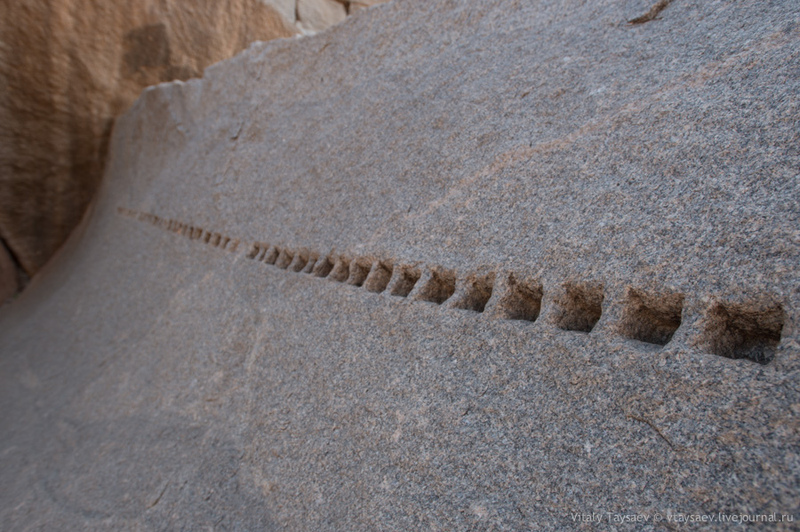
A reasonable question arises: “How did the craftsmen cut and process durable and dense granite?” Many pseudoscientists claim that ancient peoples cut these huge boulders with lasers or incredible space technologies.
“A thousand columns” stretch along the road. Their purpose is not known for certain. It remains to be assumed that there used to be covered shopping arcades for the city market here.

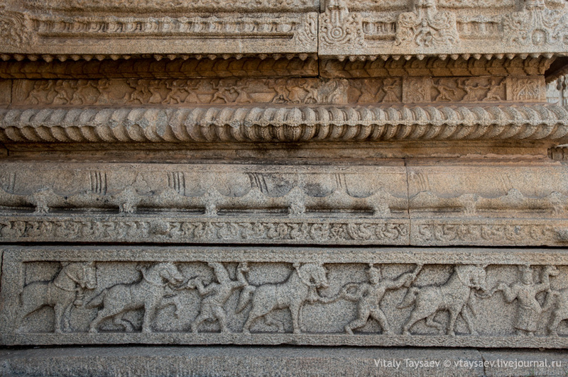
This is a real masterpiece of stone carvers - a granite chariot. Now you can see that there are elephants in harness. However, before there were horses in their place

Hampi
Culture of Harappa and Mohenjo-daro
Mohenjo-daro
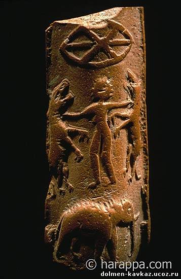
Hercules on the seals of the city
Dishes from Mohenjo-Daro


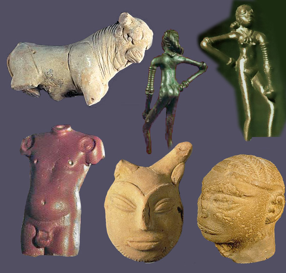
Harappan culture
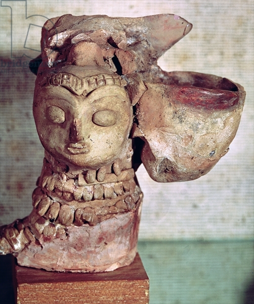
Priest

On the streets of Mohenjo-daro
decoration from Mohenjo-daro

Tools

Desk lamp
In all likelihood, the Harappans traded with the Sumerians. The Sumerian writings mentioned cities with which they traded. Among them was a city called Meluke; scientists identify it with the proto-Indian city of Mohenjo - Daro. Large quantities of remains of cotton fabrics, a variety of earthenware beads, and shells were found on Harappan territory - all of this was of foreign origin.
Excavation at Mohenjo-daro
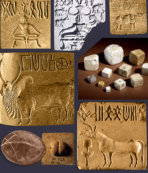
Seals from Mohenjo-Daro

Pottery and textile tools were found among the ruins. Pottery workshops were located throughout the city. Almost everything was made there, from pipes and bricks to thin-walled vessels, elegant figurines and jewelry. Residents also used objects made of copper, tin, and bronze - these were tools, jewelry and weapons. True, the weapon was made very crudely; there was probably no military action in this territory. The Harappan people were never able to master iron smelting.
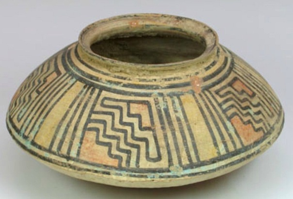
Harappan pottery

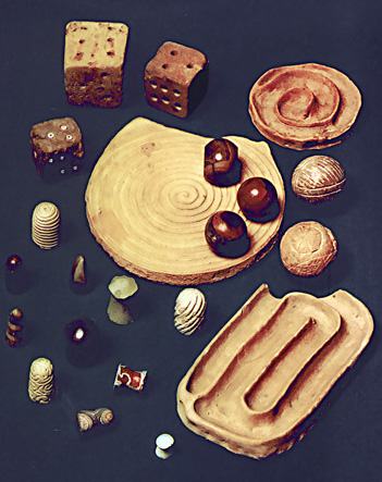
Harappan game

Pre-Harappan culture
Harappan figurines
Harappan pottery

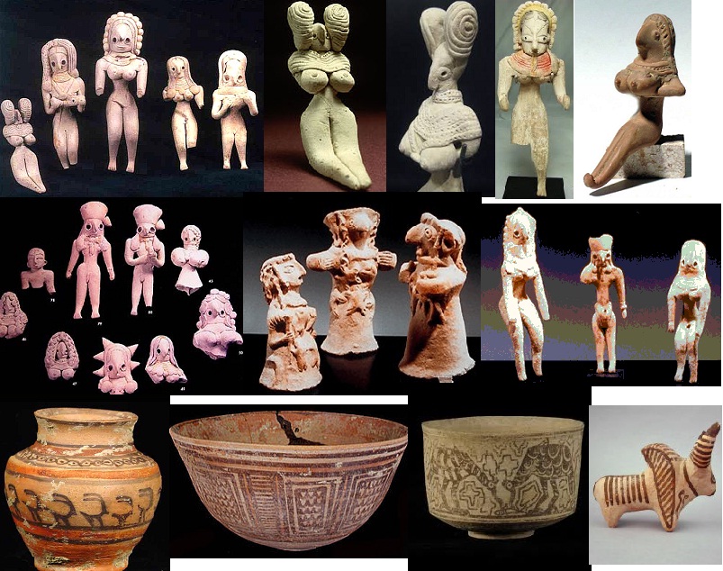
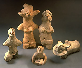
Terracotta figurines from Harappa
Terracotta


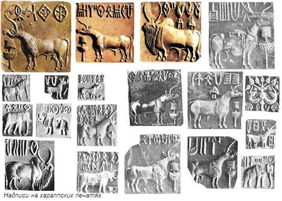
Harappan script

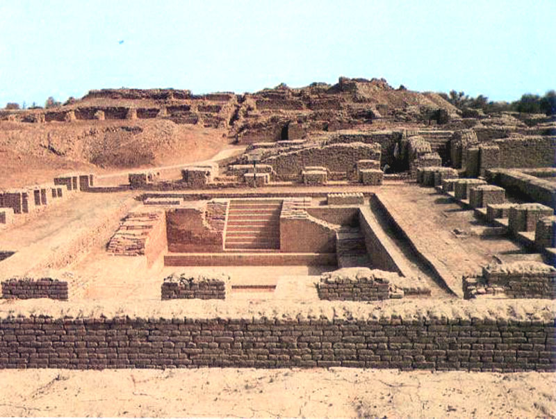
One or two rooms for ablutions (in a modern way, two bathrooms), ventilation ducts. No air conditioners have been found yet.
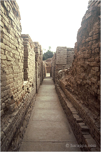
An incredibly advanced system separate sewers with sedimentation tanks and even... public toilets. Water supply. Rainwater was drained from the roofs through specially shaped pottery pipes so that splashes would not fall on passers-by. The walls were plastered, but all this, the decoration, the paint and the upper floors, had disappeared.
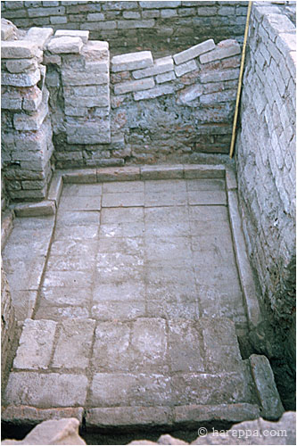
The quality of the masonry is unusually high, includes many techniques (no arched vault), and stone slabs for chic. Here is a room on the second floor
Harappa

The houses had 2-3 floors, at least 8x9 m, at least one courtyard and wells. This is not a tower, this is a well (cistern?) from the second floor.
Harappa

Harappa
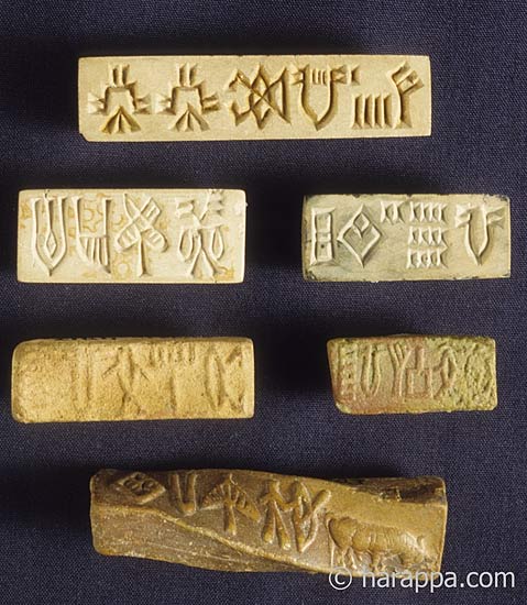
Hieroglyphs from Harappa


The decline of civilization was apparently due to natural causes. Climate change or earthquakes could change the flow of rivers or dry them up, and the soils become depleted. The farmers were no longer able to feed the cities, and the inhabitants abandoned them. The huge social and economic complex disintegrated into small groups. Writing and other cultural achievements were lost. There is nothing to suggest that the decline occurred overnight. Instead of empty cities in the north and south, new settlements appeared at this time, people moved east, to the Ganges valley.

The floors of rich houses are also brick, the swimming pools are coated with bitumen. Some floors are covered with an unknown glassy composition, and under some there are channels for air heating

City plan

Ceramics. Mohenjo-Daro. 4500 Sun.
Clay seal from Harappa but not yet deciphered.

The Indus Valley Civilization was a largely urban culture, trading with the Sumerians from southern Mesopotamia.
By far the most exquisite, and rare, artifact found to date is a small, square-shaped seal with an engraving of an animal. Despite the efforts of philologists from all parts of the world, and despite the use of computers, the content of the text remains undeciphered.
Although historians agree that civilization declined sharply, there is disagreement over possible reasons its completion. Conquerors from Central and Western Asia, according to some historians, were the cause of the disappearance Indus Valley civilization, but this opinion is open to discussion and debate. More plausible explanations are repeated floods caused by tectonic movements of the earth, soil salinization, and desertification.
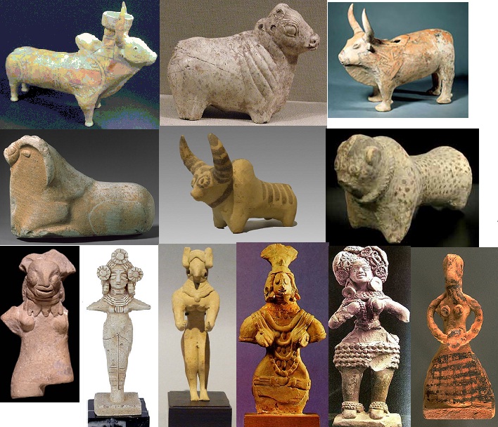
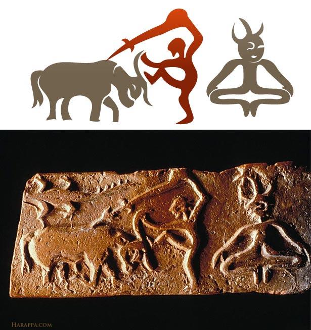
Bulls harnessed to a cart. Children's toy found in Harappan civilization excavations

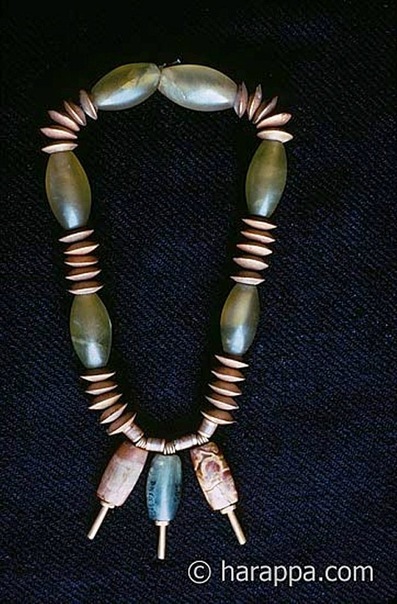
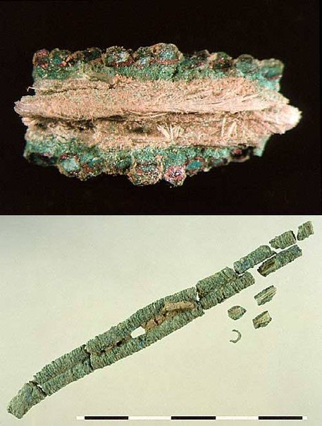
Necklace made of spiral copper wire. Traces of silk remain inside. These are the earliest traces of the use of wild silkworm fibers in South Asia. Harappa 3B: around 2450 - 220 BC
Harappan figurines
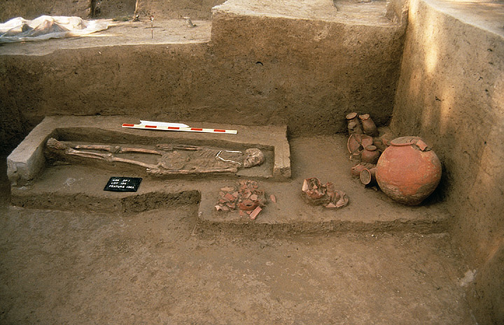
A female burial site disturbed by ancient robbers. A baby is buried under the mother's feet. Harappa is one of the two capitals of the ancient civilization in the Indus River basin.


To determine where is Ancient India on modern map, it’s worth first defining what exactly is considered such. The vast majority of modern scientists are inclined to recognize the Harappan culture, which arose in the north-west of the Indian subcontinent in the Indus River valley, as the first Indian civilization. The oldest traces date back to 3300 BC.
Geography of India
When answering the question of where India is located, it is worth starting with its place on the continent of Eurasia. The country is located in the southern part of Asia, and most of its territory is located on the Hindustan Peninsula, which is washed by the Bay of Bengal in the southwest and the Arabian Sea in the southeast.
The geological history of India, which began more than seventy-five million years ago, contributed to the formation of a rather distinctive region in geological, geographical and biological terms, which is today called the Indian subcontinent.
The separation of the subcontinent is facilitated not only by the waters washing it on both sides, but also by the mountain ranges of the Himalayas, which are the highest mountains on the planet. It is in the Himalayas that the “peak of the planet” is located - Mount Chomolungma, also known as Everest. Elevation plays a role natural border between India and China.
Ancient history of India
The region where India is located has become one of the centers of origin ancient civilizations East. In terms of age, he is second only to the Sumerians and Egyptians. The culture arose in the north-west of the subcontinent, but by the 6th century, many independent principalities emerged in the entire north of India, which went down in history under the name Mahajanapadas.
By the 3rd century BC, the Mauryan Empire appeared on the territory of India, which quickly subjugated almost all of South Asia: from Afghanistan to modern Banladesh. The empire did not last long, but it was replaced by other, successive governments. This is how the Greco-Indian, Indo-Scythian, Parthian-Indian and Kushan kingdoms existed.
Each of these states not only introduced elements of their culture into Indian culture, but also contributed to the spread of elements of Indian culture to neighboring regions. Traces of the cultural influence of this ancient civilization can be found in Iranian culture, in Roman and, of course, in Greek.
Foreign conquest
In the 10th century AD, the peninsula where India is located was invaded by passionate Islamic conquerors, who quickly conquered most of the peninsula and established the hegemony of Islam over a vast territory.
The region's first Islamic dynasty was the Delhi Sultanate, which existed from 1206 to 1526. The Sultanate was replaced by the Mughal Empire, which managed to maintain the dominant position of Islam for another two centuries, however, it too fell into decline, and was replaced by the Hindu Maratha Empire, created in 1624.
However, already in the 16th century, European merchants began to penetrate into the region where India is located, extremely interested in trading with a huge rich country. Portugal, France and the Netherlands have made their own attempts. However, the greatest success was achieved by Great Britain, which by the middle of the 19th century subjugated most of the country, starting its conquest with small fragmented principalities.
However, the Portuguese colonists also managed to achieve some success. They subjugated the territory in India where Goa is located. Portuguese administration existed on the site of the modern state until December 18, 1961, when Indian troops suppressed the resistance of the Portuguese and occupied the territory of the former Portuguese colony. However, Portugal recognized Goa's accession to India only in 1974.
Another Portuguese possession in South Asia was the coast where Kerala is located in India. Today it is a state with one of the highest population densities in the entire country. And it is located on the Malabar coast.
East India Company
To conquer India, Britain chose an already proven technology - it attracted private capital and technology that could effectively capture new markets and bribe local rulers.
The British East India Company was created for this purpose. The name of this large corporation indicates that the monopoly was engaged in trade in eastern India, that is, on the Hindustan Peninsula.
In this case, it is necessary to clarify where the West Indies are located in order to avoid the traditional confusion.
Historically, the West Indies are the islands located off the coast South America in the Caribbean Sea and the Gulf of Mexico. First of all, we usually talk about Cuba and Antigua.
Towards decolonization
Despite the fact that the liberation of India from foreign oppression and the beginning of decolonization was a positive event, it turned out that it could also have extremely negative consequences.
In 1946, a series of military mutinies demonstrated to the British authorities that they were no longer able to control the vast overseas territories in India, and the subsequent parliamentary elections once again demonstrated the need to begin moving towards the independence of the huge country.
The first active participants in violent resistance to the British military were Muslims, who proclaimed the day of direct action in 1946. As a result of this action, a series of bloody clashes between Hindus and Muslims swept across the country. The need to partition India along religious and ethnic lines became obvious not only to the local population, but also to Her Majesty's Government.
Partition of India
On August 15, 1947, Great Britain announced the creation of the Dominion of Pakistan, and the very next day it became known that the Indian Union had declared independence. This decision led to extremely bloody events and clashes, in which about a million people became victims, and another eighteen million were forced to leave their homes and move to other regions.
The decision to divide British possessions before India declared sovereignty was taken so that the creation of Pakistan would not look like its separation from sovereign India. Thus, both countries had equal rights and should not have claims against each other. However, this solution to the issue did not help to avoid territorial disputes in the future.
As a result of such large migration flows, a huge number of problems have arisen. The city of Delhi, where between one and two million people settled, experienced the greatest burden. Large quantity people were unable to find permanent housing and were forced to settle in refugee camps.
However, soon the government new country began an active program to build permanent houses in place of the tents.
Economy of India
The part of the world where India and China are located is of great importance for the modern international economy. Both countries GDP volume They are one of the three largest economic powers, second only to the United States. However, the size of the economy should not be misleading, as over the past decades, India has accumulated numerous problems that have not yet been resolved.
The level of social inequality and poverty in the country is extremely high, and traditional customs take precedence over secular laws in many regions.
Most economists agree that despite the authorities’ significant efforts to modernize, the state’s economy still has an agrarian-industrial character and does not reach the post-industrial level.
Social structure
The caste system of society still continues to have a significant impact on all spheres of social and economic relations. People are born, raised and die inside it. Each of these stages is marked by rituals characteristic of a particular caste. Even the names of the child are given in accordance with his social status.
Until recently, any Indian, when applying for a job, was required to indicate in the appropriate column not only his religion, but also the caste to which he belongs. Marriages between people belonging to different strata were not registered, and if young people still dared to connect their destinies, then there could be no question of recognition of such marriages by society.
In addition, one of the most cruel customs practiced until recently in the country was the ritual self-immolation of widows.
However, some economists, who are not very progressive in their views, believe that such a system, which developed many centuries ago, contributes to the better functioning of the traditional economy. However, in this case it remains open question about why traditional economics is needed in the 21st century.
www.syl.ru
The ancient city of Lothal, which arose 2400 years ago. BC
In the southern Indian state of Karnataka, on the banks of a river with the unpronounceable name Tungabhadra, among mighty granite boulders, there are the ruins of the capital of the once powerful Vijayanagar Empire. The remains of Vijayanagara belong to the UNESCO World Heritage Sites, where they are listed as "Hampi Monuments". It seems that nature itself has given people a scoop and a sandbox to realize their desires and ambitions. Outcrops of gray coarse granite in the heart of the Deccan plateau, the presence of waterways and fertile soil have attracted people here since the 1st century AD.
It was once home to almost half a million people and was one of the largest cities in India.
Various crafts, literature, music and architecture have achieved the greatest development here. Countless travelers from all over the world have tried in vain to describe the wonders of Vijayanagara.
A reasonable question arises: “How did the craftsmen cut and process durable and dense granite?” Many pseudoscientists claim that ancient peoples cut these huge boulders with lasers or incredible space technologies.
“A thousand columns” stretch along the road. Their purpose is not known for certain. It remains to be assumed that there used to be covered shopping arcades for the city market here.
This is a real masterpiece of stone carvers - a granite chariot. Now you can see that there are elephants in harness. However, before there were horses in their place
Culture of Harappa and Mohenjo-daro
Mohenjo-daro
Hercules on the seals of the city
Dishes from Mohenjo-Daro
Harappan culture
On the streets of Mohenjo-daro
decoration from Mohenjo-daro
Tools
Desk lamp
In all likelihood, the Harappans traded with the Sumerians. The Sumerian writings mentioned cities with which they traded. Among them was a city called Meluke; scientists identify it with the proto-Indian city of Mohenjo - Daro. Large quantities of remains of cotton fabrics, a variety of earthenware beads, and shells were found on Harappan territory - all of this was of foreign origin.
Excavation at Mohenjo-daro
Seals from Mohenjo-Daro
Pottery and textile tools were found among the ruins. Pottery workshops were located throughout the city. Almost everything was made there, from pipes and bricks to thin-walled vessels, elegant figurines and jewelry. Residents also used objects made of copper, tin, and bronze - these were tools, jewelry and weapons. True, the weapon was made very crudely; there was probably no military action in this territory. The Harappan people were never able to master iron smelting.
Harappan pottery
Harappan game
Pre-Harappan culture
Harappan figurines
Harappan pottery
Terracotta figurines from Harappa
Terracotta
Harappan script
One or two rooms for ablutions (in a modern way, two bathrooms), ventilation ducts. No air conditioners have been found yet.
An incredibly developed system of separate sewage systems with septic tanks and even... public toilets. Water supply. Rainwater was drained from the roofs through specially shaped pottery pipes so that splashes would not fall on passers-by. The walls were plastered, but all this, the decoration, the paint and the upper floors, had disappeared.
The quality of the masonry is unusually high, includes many techniques (no arched vault), and stone slabs for chic. Here is a room on the second floor
The houses had 2-3 floors, at least 8x9 m, at least one courtyard and wells. This is not a tower, this is a well (cistern?) from the second floor.
Hieroglyphs from Harappa
The decline of civilization was apparently due to natural causes. Climate change or earthquakes may have altered the flow of rivers or dried them out and depleted the soils. The farmers were no longer able to feed the cities, and the inhabitants abandoned them. The huge social and economic complex disintegrated into small groups. Writing and other cultural achievements were lost. There is nothing to suggest that the decline occurred overnight. Instead of empty cities in the north and south, new settlements appeared at this time, people moved east, to the Ganges valley.
The floors of rich houses are also brick, the swimming pools are coated with bitumen. Some floors are covered with an unknown glassy composition, and under some there are channels for air heating
City plan
Ceramics. Mohenjo-Daro. 4500 Sun.
Clay seal from Harappa but not yet deciphered.
The Indus Valley Civilization was a largely urban culture, trading with the Sumerians from southern Mesopotamia. By far the most exquisite, and rare, artifact found to date is a small, square-shaped seal with an engraving of an animal. Despite the efforts of philologists from all parts of the world, and despite the use of computers, the content of the text remains undeciphered. Although historians agree that the civilization declined sharply, there is disagreement about the possible reasons for its end. Conquerors from Central and Western Asia are believed by some historians to be the reason for the disappearance of the Indus Valley Civilization, but this opinion is open to debate and debate. More plausible explanations are repeated floods caused by tectonic movements of the earth, soil salinization, and desertification.
Bulls harnessed to a cart. Children's toy found in Harappan civilization excavations
Necklace made of spiral copper wire. Traces of silk remain inside. These are the earliest traces of the use of wild silkworm fibers in South Asia. Harappa 3B: around 2450 - 220 BC
Harappan figurines
A female burial site disturbed by ancient robbers. A baby is buried under the mother's feet. Harappa is one of the two capitals of the ancient civilization in the Indus River basin.
raskopkivostok.mirtesen.ru
Maps of India | India Travel Guide/Travel to India: General Information
1. Geographical (graphic maps) of India
for fans of traditional maps: 1.1. Big tourist map India, which lists all the major cities and marks with stars the major tourist attractions of interest to travelers. This map will help you understand where the places you want to go are and create an idea of the geography of India1.2. Detailed geographical map India, indicating in addition to cities also meridians, rivers, mountain systems, etc. This map is quite detailed and very large; to view the map, click on the preview and it will open in a new window.
2. Interactive travel map of India and Asia
On the Indonet there is interactive map India (and Asia too), which marks all the places indicated in this guide, as well as stories and other materials written by travelers, with direct links to them from the map. That is, the map itself indicates how many materials there are; by enlarging the map by scrolling to a city or attraction, you will see the number of posts about this place.3. Interactive map of India
Unlike graphic and scanned maps, the interactive map of India from maps.google.ru allows you, thanks to navigation, to look around the whole of India and even find a village, see Indian national highways and local access roads, as well as plans of large Indian cities with names of streets and hotels. Different flags on this map of India indicate places for which there is information in the guidebook, the names of places are naturally in Russian. View See the map of India "India in Russian" on a larger map Navigation maps for gps are laid out for each state separately, you can find and download links to maps of Indiaindonet.ru
Ancient cities of India - India, culture, cities, description
The ancient cities of India are unique and inimitable in their beauty. After all, Indian civilization is one of the oldest in the world. The oldest cities in India known to us are Varanasi, founded, according to Indian legends, by Shiva himself on the banks of the Ganges fifty centuries ago.
City of Kashi-Varnasi The next city is Madurai. It was built around the Meenakshi temple and the temple is right in the center of it. This temple is in the photo:Another ancient city is Ujjain, where the so-called festival of pitchers - Kumbh Mela - is held every twelve years. Another couple of attractions in the city are a Shaivist temple and an observatory.
View of Ujjain city from the river
Also, the oldest city in India is Patna - a place of pilgrimage for many Indian believers. Patna is a continuously inhabited city, like many other ancient cities of India.
Modern Patna
The city of Pushkar is the smallest city in India, but no less ancient. It is famous for its camel fair.
Excavations of ancient cities of India, locations.
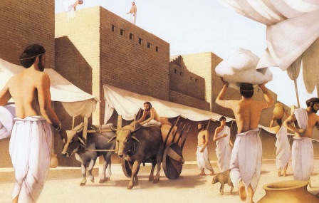
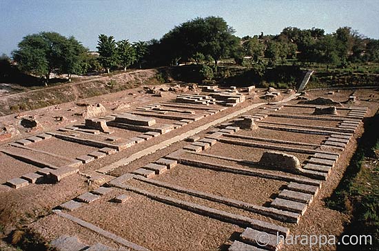
The sites of the oldest cities in India are mainly the valleys of the Indus and Ganges rivers. Most ancient city India was excavated by archaeologists in the Mohenjo-Daro region. More than five thousand years ago the city was inhabited. The city had straight streets running from west to east and from north to south. The city had a sewerage system, and residents also had wells. The buildings were made of brick. Residents also had pets. Many tools, as well as jewelry and figurines, were found in the city. Now this territory is uninhabited - Mohenjo-Daro is translated as “hill of death.”
Excavations at the "Hill of Death"
india-onlain.ru
Detailed map of India in Russian. Where is India located on the world map.
India is located in southern Asia, mostly on the Hindustan Peninsula, less on the continental part. India also includes numerous islands located in the east - in the Bay of Bengal, in the south - in the Indian Ocean, in the west - in the Arabian Sea. India shares borders with Pakistan in the west, with Bhutan, Nepal and China in the northeast, and with Bangladesh and Myanmar in the east. General boundaries The Indian states of Jammu and Kashmir have disputed territories with Afghanistan. The country has maritime borders with the Maldives in the southwest, with Indonesia in the southeast, and with the islands of Sri Lanka in the south.
In terms of territory, the country is in seventh place in the world. Total area is 3.3 million square kilometers, which includes 90.44% land and 9.56% water surface. India ranks second in population in the world - 1.2 billion people live in the state. About 70% of Indians live in rural areas.
The majority of India's population professes the Hindu religion - about 80%, Muslims make up 14% of the total population, Christians - 2.4%, Sikhs - about 2%, Jains and Buddhists - less than 1%. There are also other religions in the country - Zoroastrianism, Judaism, Baha'i.
State language India's languages are English and Hindi. In different states, other languages are used as official languages: Tamil, Kannara, Telugu, Bengali, Urdu and others. The population of India speaks more than 1,600 languages and dialects.
In India, administrative divisions include Delhi district, six union territories and 28 states. All union territories and states are divided into districts, which are divided into tuluks. The largest cities: Mumbai - about 10 million people, New Delhi - about 7 million people, Kolkata (formerly Calcutta) - about 4.5 million people. The major cities are Hyderabad, Madras, Bangapore, each with a population of about 4 million people.
Detailed physical map India in Russian with main cities.
See where India is on the world map:
Sorry, the card is temporarily unavailable
webmandry.com
Sights of India. Photo and description on Tourister.Ru.
India: useful information
Ancient sights of India
The outstanding monuments of Ancient India are the cave temples of Ajanta and Ellora, located 60 km from each other in the state of Maharashtra. The first temples at Ajanta were carved over several centuries, starting from the 2nd century BC. The cave village of Ellora was created later, but is just as impressive in its scale: the complex includes 34 caves, and its central structure is the colossal Kailasanatha Temple. Cave temple complexes, many sculptures, and the remains of ancient paintings were also found on Elephanta Island in the Mumbai waters of the Arabian Sea.
Among the main treasures of India protected by UNESCO is the Abandoned City of Hampi. It was in these places that some of the events described in the Ramayana unfolded. The Virupaksha Temple located in Hampi is still active.
In Amritsar, in the center of the artificial lake of the same name, stands the Sikh Golden Temple Harmandir Sahib, which can be reached over a narrow marble bridge.
For many travelers, imbued with the ideas of Buddhism, ancient temples scattered throughout the country become the strongholds of their travel.
In addition, get inspired by Indian culture and centuries-old traditions in the Old Town of Gokarna, consisting almost entirely of wooden houses, or in Little Tibet, the largest Buddhist community in India.
Panoramic view of the Taj Mahal from Airpano.com
Sights of Indian cities
In the capital Delhi, the most interesting are temples of different religions, the Red Fort and city parks. Here is the Lotus Temple, central to the Bahai religion, as well as the National Museum, which has the largest collection of artifacts in India. More attractions of Delhi can be viewed in the thematic section.
The most popular Indian resort state of Goa should not be perceived only as a place for a beach holiday. If you wish, you can create a completely varied excursion program, visiting Indian attractions: temples, churches and mosques, museums, historical quarters. For example, the Basilica of Jesus in Old Goa, the elegant architectural ensemble of Largo da Igreja in Panaji, main temple Goa - Sri Mangeshi. The resorts are close to the beautiful Dudhsagar waterfall - the second largest in India. Best place for walking and buying souvenirs - 18th June Street in Panaji.
Mumbai is the capital of the Indian film industry, where the Bollywood pavilions are located. The attention of tourists is attracted by the huge triumphal arch - the Gateway of India, and the Flora Fountain in the ancient Roman style. Guided tours include visiting the planetarium of the Nehru Scientific and Cultural Center, located in a prominent modern building. The largest exhibition in the city is presented at the Prince of Wales Museum. The best place to relax with children is the huge water park and amusement park Esselworld.
India's most recognizable architectural landmarks in Jaipur, the "Pink City", are located in the old quarter, where most of the stone houses have a distinctive pink or terracotta hue. The city is home to the grand Maharaja's Palace, the Albert Hall Museum, originally designed as a city assembly hall, and the huge Jantar Mantar observatory. In the suburbs of Jaipur stands the legendary Amber Fort, where a museum and observation deck.
Famous sights of Kolkata (Kolkata) are the Kali Temple, India's largest zoo - Alipore, the ancient Indian Museum, where, among other exhibits, ancient fossils and meteorites are kept, the Victoria Memorial and St. Paul's Cathedral.
Video about the sights of India
It is one of the most colorful and original in the world. The diversity of spiritual and philosophical teachings, ancient architecture, and the beauty of nature attract people. There is a desire to visit the territory where India is located - the land of the ancient Vedas. This is a country where the beauty and grandeur of the temples amaze, and the music and magical atmosphere immerse you in a world of mystery and sensuality.
India on the world map
Where is India located on the world map? IN geographically The country is adjacent to South Asia and occupies a significant part of the Hindustan Peninsula. India has a lot of neighbors - states. In the northwest, the country borders Pakistan and Afghanistan. In the northeast - with China, Nepal and Bhutan. The Indian-Chinese border is the longest and it runs along the main Himalayan range. In the east it borders with the states of Bangladesh and Myanmar. India has maritime borders in the southwest with the Maldives, in the south with Sri Lanka and in the southeast with Indonesia.
The area of the country is quite large and amounts to 3.3 million square meters. km. In the east, south and west, the peninsula is washed by the Bay of Bengal, the Laccadive and Arabian Seas. Large rivers India is the Ganges, Brahmaputra, Godavari, Indus, Krishna, Sabarmati.
Since the country's territory is large and has different topography, the climate in different regions is different.
Where is India covered with snow? In the northern part of the country are the Himalayas - one of the highest mountain systems. Here the mountain tops and valleys are covered with snow. In the east of the country is the Ganges Valley. The Indo-Gangetic Plain is located in the eastern and central parts of the country, and the Thar Desert adjoins it to the west.
State name
Where is India, whose name has changed several times? In ancient times it was called “the country of the Aryans,” “the country of the Brahmans,” and “the country of the sages.” Modern name The state of India comes from the name of the Indus River, the word “Sindu” translated from ancient Persian means “river”. The country has a second name, translated from Sanskrit it sounds like Bharat. This name is associated with the story of an ancient Indian king, which is described in the Mahabharata. Hindustan is the third name of the country; it has been used since the reign of the Mughal Empire, but it has not been given official status. Republic of India - official name country, it appeared in the 19th century.

Ancient India
In the territory where ancient India was located, one of the oldest civilizations in the world was born. Its history includes two periods. The first is the period of the Harappan civilization, which began its development in the Indus River valley. The second period is the Aryan civilization, associated with the appearance of Aryan tribes in the valleys of the Ganges and Indus rivers.
In the Harappan civilization, the main centers were the cities of Harappa (modern Pakistan) and Mohenjo-Daro (“ Hill of the Dead"). The level of civilization was very high, as evidenced by the construction of cities with a well-planned layout and a drainage system. Writing was developed, and small plastic arts developed in artistic culture: small figurines, signets with reliefs. But the Harappan culture declined, due to climate change, river flooding and epidemics.

After the Harappan civilization ended, Aryan tribes came to the valleys of the Ganges and Indus rivers. Their appearance inspired new life into the Indian ethnic group. The Indo-Aryan period begins from this period.
The main asset created by the Aryans of that period was a collection of texts - the Vedas. They are written in the Vedic language - the oldest form of Sanskrit.
Culture of Ancient India
The territory where India is located is the place of origin and development of religious and philosophical teachings. Culture ancient country is closely connected with the secrets of the universe. Since ancient times, people have asked questions to the Universe, trying to unravel the meaning of existence. A special place is occupied by the teaching of yoga, where self-immersion into the world of the human soul occurs. The uniqueness of the culture lies in the fact that music and dance are a companion to any event or event. The originality and diversity of culture was largely due to the fact that both local peoples and newcomers took part in its formation.
The culture of Ancient India dates back to the period from the middle of the 3rd millennium BC. and until the 6th century. AD
The architecture of this period has its own characteristics. Not a single monument of ancient Indian culture has survived. This is caused by the fact that building material from that period there was a tree that has not survived to our time. And starting from the 3rd century. BC stone is being used in construction. Architectural buildings from this period have survived to this day. The main religion of this period was Buddhism, and therefore characteristic structures were erected: stupas, stambhas, cave temples.
The culture of Ancient India occupies an important place in world history. It had a greater influence on the entire world development.

Agra
The ancient city of Agra was founded in the 15th century. It is located on the banks of the Yamuna River. The city of Agra is very large, and in order not to get lost, you need a map. The walls of the ancient city will tell you where India was located during the reign of the Mughals. The capital of the Mughal Empire had many palaces, parks, and beautiful gardens.
Agra is an ancient city imbued with national flavor. Here you can see and learn the traditions of the Indian people, plunge into the world national cuisine, purchase souvenirs made using the Florentine mosaic technique - Pietra Dura, which has been a national craft since the times of the Great Mughals.
The center of Agra, like many Indian cities, is a huge market. The city is home to one of the largest spa centers in all of Asia, Kaya Kalp.

Taj Mahal
India has one of the seven wonders of the world. The Taj Mahal, where the mausoleum of one of Shah Jahan's most beloved wives, Mumtaz Mahal, is located, is one of the landmarks of Agra. An architectural structure like this has not been seen in the last 400 years.
The Taj Mahal is a monument to love and translated from Hindi means “Crown of Palaces”. He became the last gift for his beloved. The palace took 22 years to build; marble for it was mined 300 km away. The walls of the tomb are decorated with mosaics of precious and semi-precious stones, although when viewed from a distance, the color of the mausoleum appears white. The proportions of the structure are perfect. Even the fact that his minarets were rejected is not accidental. This was done so that in the event of an earthquake the minarets would not fall on the mausoleum.
The Taj Mahal is a gem of Indian culture that embodies the love and wealth of the Mughal Emperor Shah Jahan.
India is one of the largest countries South Asia. Most of its territory is located on the Hindustan Peninsula. The southern part of the republic is washed by the Indian Ocean. The northern and northeastern parts are surrounded by the highest mountain system on the planet - the Himalayas. The northwestern region is located in the Thar Desert.
Physical card

Physical map of India (schematically shown) shows settlements, major rivers of India and communication routes.
The satellite clearly demonstrates the features of the country's topography.
Outline map

To organize the information received, below is presented contour map, with boundaries marked on it and major cities. Here you can see where India is located on the world map and how its borders lie.

Economic map of India - another one good helper in getting to know the country. The economic map of India shows which regions are employed and in what volumes various types industry and agriculture. But the country's main income comes from the service sector.

Today the Republic ranks second in the world in terms of population. But according to forecasts, the population of India, by 2028, has every chance of catching up with the number of its neighbors from the Middle Kingdom.
A detailed map of India will show the location of the largest cities:
- Mumbai;
- Delhi;
- Bangalore;
- Calcutta;
- Chennai.
The history of settlement of some of them begins after the end of the 16th century (in the 16th century, European countries began to fight to colonize the territory). And some of them began their development even before our era.
One cannot ignore the places of the most ancient cities of India:
- Madurai;
- Varanasi;
- Patna;
- Pushkar;
- Ujjain.
Each ancient Indian city has its own customs and traditions, legends and beliefs.
Goa on the map of India is located in the southwestern part.
Another popular tourist destination is Kerala. On the map of India, Kerala is located in the very south. The largest one located here national park, tiger reserve, Vishnu temple and butterfly garden make this place in highest degree attractive for tourists.
For those who are interested in a variety of beaches, unique resorts are indicated below - on the map of India.
Airports in India are shown on the map below.

Rivers and ocean

The Indian Ocean is one of the largest and deepest on the planet - it ranks third. All the seas, straits and bays that make up it total 11.68 million square kilometers. The country's shores are washed by the Arabian Sea and the Bay of Bengal.
Large rivers flow into the latter:
- Ganges;
- Godavari;
- Brahmaputra;
- Kaveri;
- Krishna;
- Mahanadi.

The main rivers are the Indus and the Ganges.
India Hotel Map

Among the most popular hotels stand out:
- The Taj Mahal Palace, Mumbai;
- Courtyard Agra, Agra;
- The Lalit New Delhi, New Delhi;
- ITC Rajputana, Jaipur;
- Abhimaani Vasathi, Bangalore.

It neighbors Myanmar, Bangladesh, Bhutan, Nepal, China and Pakistan on its eastern, northeastern and western borders respectively. The state of Jammu and Kashmir in the northern part has autonomous status, partly under the control of Pakistan and China.
Climate and weather

Most of the territory is characterized by three periods with their own climatic characteristics:
- From June to October is the rainy season and fairly high air temperatures;
- From November to February – cool, windy weather;
- From March to May is a very hot period.
Road map

The map of national roads shows:
- The Golden Quadrilateral (yellow-orange line) is a highway connecting the main cultural, industrial and agricultural centers of the country;
- North-South Transport Corridor (orange line);
- West-East transport corridor (green line);
- Gray lines are national backbone networks.
Provinces and regions

Administratively, the Republic is divided into states (currently there are 29), union territories (there are six) and the capital region of Delhi (the capital of India is New Delhi). On the map of India, the states are indicated by different colors.
The next type of administrative division is districts, or okrugs. There are currently 642 districts, but new ones are constantly appearing.
The districts are in turn subdivided into smaller areas called talukas.
In regional terms, the following territories can be distinguished:
- Northern;
- Western;
- Eastern;
- Northeast;
- South.
The most exotic beaches in India include South India. The northeastern part of the country is for adventure lovers. The Western region is a place with beautiful landscapes, a milder climate and unique historical monuments. The population density here is the highest.
Having absorbed many different cultures and traditions, possessing unique and diverse natural objects, India is an ideal place for an unforgettable holiday.

Interesting facts:
- Chess, pi and the decimal system appeared here;
- At a time when most of the world's population led a nomadic lifestyle, the Harappan civilization was already flourishing here;
- Button to notify the driver about stopping at public transport(buses) is replaced by a rope with a bell tied to it;
- Quantity official languages– 21. Plus, “auxiliary” English;
- In addition to the main four seasons, there are two more: pre-spring and monsoon seasons;
- More than a quarter of the country's population does not have reading or writing skills. Half of the total population lives in houses without sewerage or running water;
- Traffic on the roads is not regulated in any way;
- The world's first school of medicine, as well as a university, appeared here;
- Thousands of years ago, people here already consumed cane sugar and had knowledge about anesthesia, genetics, and the immune system;
- The largest amount of whiskey is produced and consumed here too.
On a modern map, it’s worth first defining what exactly is considered such. The vast majority of modern scientists are inclined to recognize the Harappan culture, which arose in the north-west of the Indian subcontinent in the Indus River valley, as the first Indian civilization. The oldest traces date back to 3300 BC.
Geography of India
When answering the question of where India is located, it is worth starting with its place on the continent of Eurasia. The country is located in the southern part of Asia, and most of its territory is located on the Hindustan Peninsula, which is washed by the Bay of Bengal in the southwest and the Arabian Sea in the southeast.
The geological history of India, which began more than seventy-five million years ago, contributed to the formation of a rather distinctive region in geological, geographical and biological terms, which is today called the Indian subcontinent.
The separation of the subcontinent is facilitated not only by the waters washing it on both sides, but also by the mountain ranges of the Himalayas, which are the highest mountains on the planet. It is in the Himalayas that the “peak of the planet” is located - Mount Chomolungma, also known as Everest. The hill acts as a natural border between India and China.

Ancient history of India
The region where India is located became one of the centers of the emergence of the most ancient civilizations of the East. In terms of age, he is second only to the Sumerians and Egyptians. The culture arose in the north-west of the subcontinent, but by the 6th century, many independent principalities emerged in the entire north of India, which went down in history under the name Mahajanapadas.
By the 3rd century BC, the Mauryan Empire appeared on the territory of India, which quickly subjugated almost all of South Asia: from Afghanistan to modern Banladesh. The empire did not last long, but it was replaced by other, successive governments. This is how the Greco-Indian, Indo-Scythian, Parthian-Indian and Kushan kingdoms existed.
Each of these states not only introduced elements of their culture into Indian culture, but also contributed to the spread of elements of Indian culture to neighboring regions. Traces of the cultural influence of this ancient civilization can be found in Iranian culture, in Roman and, of course, in Greek.

Foreign conquest
In the 10th century AD, the peninsula where India is located was invaded by passionate Islamic conquerors, who quickly conquered most of the peninsula and established the hegemony of Islam over a vast territory.
The region's first Islamic dynasty was the Delhi Sultanate, which existed from 1206 to 1526. The Sultanate was replaced by the Mughal Empire, which managed to maintain the dominant position of Islam for another two centuries, however, it too fell into decline, and was replaced by the Hindu Maratha Empire, created in 1624.
However, already in the 16th century, European merchants, extremely interested in trade with a huge rich country, began to penetrate into the region where India is located. Portugal, France and the Netherlands have made their own attempts. However, the greatest success was achieved by Great Britain, which by the middle of the 19th century subjugated most of the country, starting its conquest with small fragmented principalities.
However, the Portuguese colonists also managed to achieve some success. They subjugated the territory in India where Goa is located. Portuguese administration existed on the site of the modern state until December 18, 1961, when Indian troops suppressed the resistance of the Portuguese and occupied the territory of the former Portuguese colony. However, Portugal recognized Goa's accession to India only in 1974.
Another Portuguese possession in South Asia was the coast where Kerala is located in India. Today it is a state with one of the highest population densities in the entire country. And it is located on the Malabar coast.

East India Company
To conquer India, Britain chose an already proven technology - it attracted private capital and technology that could effectively capture new markets and bribe local rulers.
The British East India Company was created for this purpose. The name of this large corporation indicates that the monopoly was engaged in trade in eastern India, that is, on the Hindustan Peninsula.
In this case, it is necessary to clarify where the West Indies are located in order to avoid the traditional confusion.
Historically, the West Indies refer to the islands located off the coast of South America in the Caribbean Sea and the Gulf of Mexico. First of all, we usually talk about Cuba and Antigua.

Towards decolonization
Despite the fact that the liberation of India from foreign oppression and the beginning of decolonization was a positive event, it turned out that it could also have extremely negative consequences.
In 1946, a series of military mutinies demonstrated to the British authorities that they were no longer able to control the vast overseas territories in India, and the subsequent parliamentary elections once again demonstrated the need to begin moving towards the independence of the huge country.
The first active participants in violent resistance to the British military were Muslims, who proclaimed the day of direct action in 1946. As a result of this action, a series of bloody clashes between Hindus and Muslims swept across the country. The need to partition India along religious and ethnic lines became obvious not only to the local population, but also to Her Majesty's Government.

Partition of India
On August 15, 1947, Great Britain announced the creation of the Dominion of Pakistan, and the very next day it became known that the Indian Union had declared independence. This decision led to extremely bloody events and clashes, in which about a million people became victims, and another eighteen million were forced to leave their homes and move to other regions.
The decision to divide British possessions before India declared sovereignty was taken so that the creation of Pakistan would not look like its separation from sovereign India. Thus, both countries had equal rights and should not have claims against each other. However, this solution to the issue did not help to avoid territorial disputes in the future.
As a result of such large migration flows, a huge number of problems have arisen. The city of Delhi, where between one and two million people settled, experienced the greatest burden. A large number of people were unable to find permanent housing and were forced to settle in refugee camps.
However, the government of the new country soon began an active program to build permanent houses in place of the tents.
Economy of India
The part of the world where India and China are located is of great importance for the modern international economy. Both countries are among the three largest economic powers in terms of GDP, second only to the United States. However, the size of the economy should not be misleading, as over the past decades, India has accumulated numerous problems that have not yet been resolved.